


Miami is becoming more and more like New York, and that’s not just due to the migration between the two cities, or the influence that New York developers have in South Florida.
No, Miami is filling out its skyline. With more than 100 new hotel, residential, office, and retail towers and buildings in the development pipeline (projects that could be considered planned, proposed, under construction, or recently completed), the Miami Downtown Development Authority (DDA) launched a new interactive tool to keep track of it all.
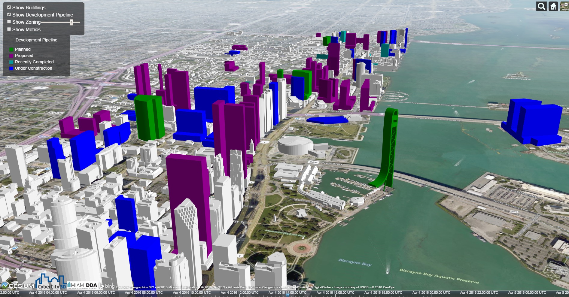
The Downtown Miami Interactive 3-D Skyline Map displays depictions of current buildings and the buildings in development on a satellite terrain of downtown Miami and the adjacent Brickell neighborhood. Clicking on a building will bring up a window that tells the address, neighborhood, developer, status, and project description, which includes features, numbers of units, and dimensions and square footage.
Some of the most notable new developments include the Zaha Hadid-designed 1000 Museum, which is currently under construction; the hairpin-shaped Skyrise Miami entertainment and observation tower planned for the waterfront; the 4.9-acre Patricia & Phillip Frost Museum of Science that’s under construction; and the proposed One Bayfront Plaza, an 80-floor tower that will have 700 condos, 620 hotel rooms, and 650,000 sf of office space.
Users can adjust the times of day to see how sunlight and shadows hit buildings. The map also shows zoning boundaries and the routes of the Metrorail rapid transit system.
The DDA will update the map each quarter as buildings are completed and as new projects are announced. The organization has another 2D map that plots all of the projects in development.
Miami certainly has a lot of real estate activity going on. The Miami Herald, which reported in October that the downtown building boom would soon be ending, wrote in late March that the city was beginning a hotel boom. Four new hotels will be built downtown by 2018.
The Wall Street Journal, meanwhile, reported that Miami is on the verge of a condo bust as sales have slipped and inventory tanked. The leak this week of the Panama Papers, which revealed offshore financial dealings, will also hurt Miami’s luxury condo scene.
The Downtown Miami Interactive 3-D Skyline Map can be accessed here.
 Miami's skyline in 2016.
 Miami's skyline after projects in development are completed. Click images to enlarge.
Related Stories

Building Technology | Oct 7, 2016
How much is that LEED point worth? A new tool provides answers
Autocase analyzes the financial, social, and environmental benefits of certification.

Sponsored | BIM and Information Technology | Oct 3, 2016
A laser scanning solution for challenging topographic surveys
DeWalt Corporation, which has completed thousands of surveys over the last 50 years, began using 3D laser scanning technology nearly five years ago.

BIM and Information Technology | Sep 15, 2016
8 tips for perfecting co-location
Experts share tips and tricks for maximizing cross-team collaboration.
BIM and Information Technology | Sep 12, 2016
Draft of 2016 version of the LOD Specification has been released for public comment
The comment period is open until Sept. 23.

BIM and Information Technology | Sep 7, 2016
Energy Star Portfolio Manager tool updated to factor in waste management
The costs and benefits of managing 29 types of waste are now included.

BIM and Information Technology | Aug 30, 2016
BIM GIANTS: A ranking of the nation's top BIM design and construction firms
HOK, Perkins+Will, Turner Construction Co., The Whiting-Turner Contracting Co., Jacobs, and Thornton Tomasetti top Building Design+Construction’s annual ranking of the nation’s largest BIM AEC firms, as reported in the 2016 Giants 300 Report.

BIM and Information Technology | Aug 30, 2016
New service from CBRE provides deeper insights into in-building wireless network experiences
With dependable cellular and Wi-Fi coverage a must-have amenity for today’s businesses, CBRE to certify in-building network quality through new Cellular Signal Mapping service

BIM and Information Technology | Aug 22, 2016
The wicked problem of interoperability
Building professionals are often put in a situation where solving problems with the ‘best tool for the job’ comes at the cost of not being able to fully leverage data downstream without limitation, writes Proving Ground's Nathan Miller.

Contractors | Aug 10, 2016
Dodge launches new app to simplify pros' search for suitable projects to bid and work on
The product, called PlanRoom, could be particularly useful in sharing data and communications among AEC teams.

BIM and Information Technology | Aug 9, 2016
How to improve a project presentation with animated GIFs
Animated GIFs are a simple tool that can explain a large amount of intricate information in an easy to understand, streamlined manner.


