


Miami is becoming more and more like New York, and that’s not just due to the migration between the two cities, or the influence that New York developers have in South Florida.
No, Miami is filling out its skyline. With more than 100 new hotel, residential, office, and retail towers and buildings in the development pipeline (projects that could be considered planned, proposed, under construction, or recently completed), the Miami Downtown Development Authority (DDA) launched a new interactive tool to keep track of it all.
The Downtown Miami Interactive 3-D Skyline Map displays depictions of current buildings and the buildings in development on a satellite terrain of downtown Miami and the adjacent Brickell neighborhood. Clicking on a building will bring up a window that tells the address, neighborhood, developer, status, and project description, which includes features, numbers of units, and dimensions and square footage.
Some of the most notable new developments include the Zaha Hadid-designed 1000 Museum, which is currently under construction; the hairpin-shaped Skyrise Miami entertainment and observation tower planned for the waterfront; the 4.9-acre Patricia & Phillip Frost Museum of Science that’s under construction; and the proposed One Bayfront Plaza, an 80-floor tower that will have 700 condos, 620 hotel rooms, and 650,000 sf of office space.
Users can adjust the times of day to see how sunlight and shadows hit buildings. The map also shows zoning boundaries and the routes of the Metrorail rapid transit system.
The DDA will update the map each quarter as buildings are completed and as new projects are announced. The organization has another 2D map that plots all of the projects in development.
Miami certainly has a lot of real estate activity going on. The Miami Herald, which reported in October that the downtown building boom would soon be ending, wrote in late March that the city was beginning a hotel boom. Four new hotels will be built downtown by 2018.
The Wall Street Journal, meanwhile, reported that Miami is on the verge of a condo bust as sales have slipped and inventory tanked. The leak this week of the Panama Papers, which revealed offshore financial dealings, will also hurt Miami’s luxury condo scene.
The Downtown Miami Interactive 3-D Skyline Map can be accessed here.
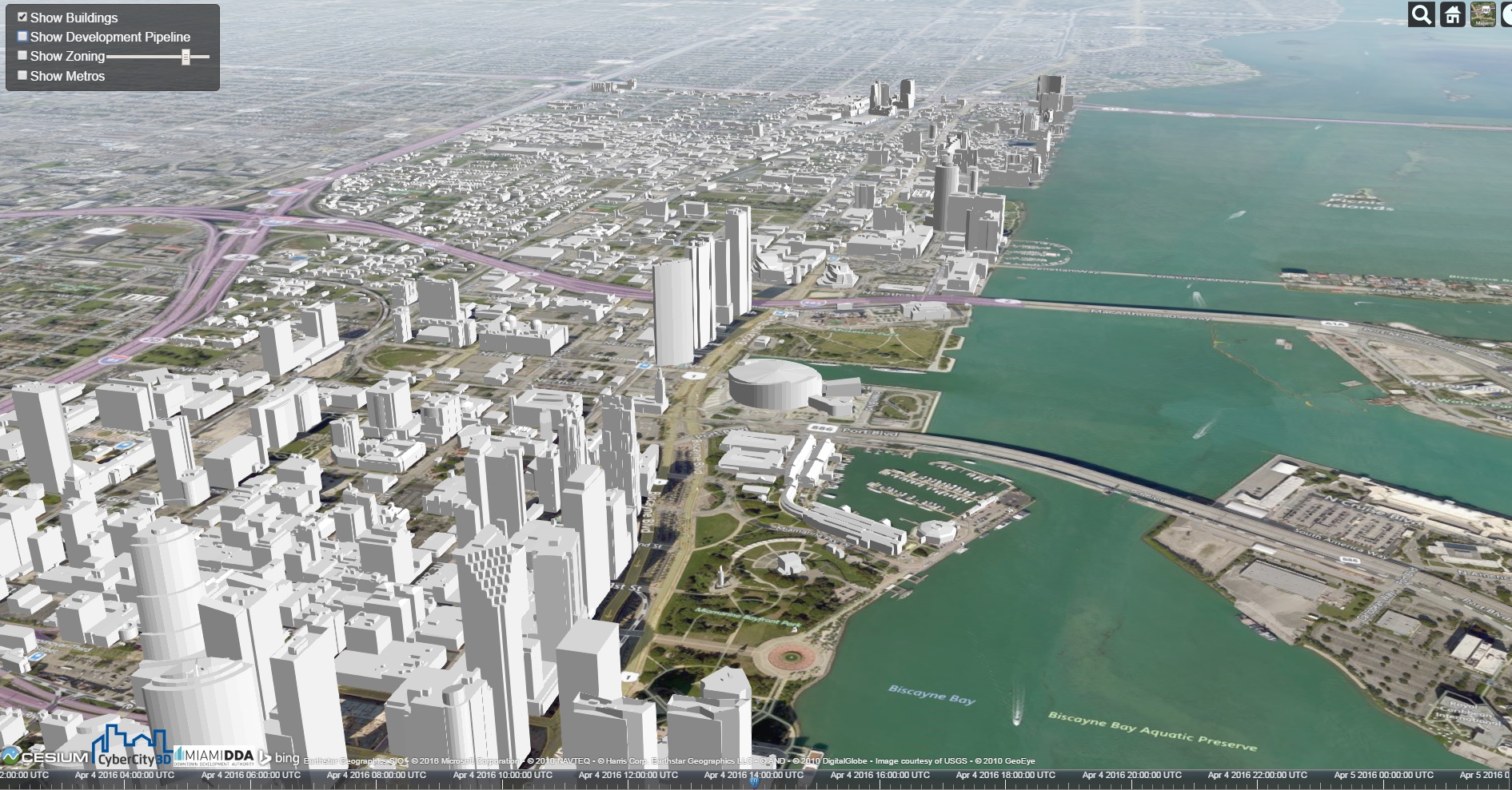 Miami's skyline in 2016.
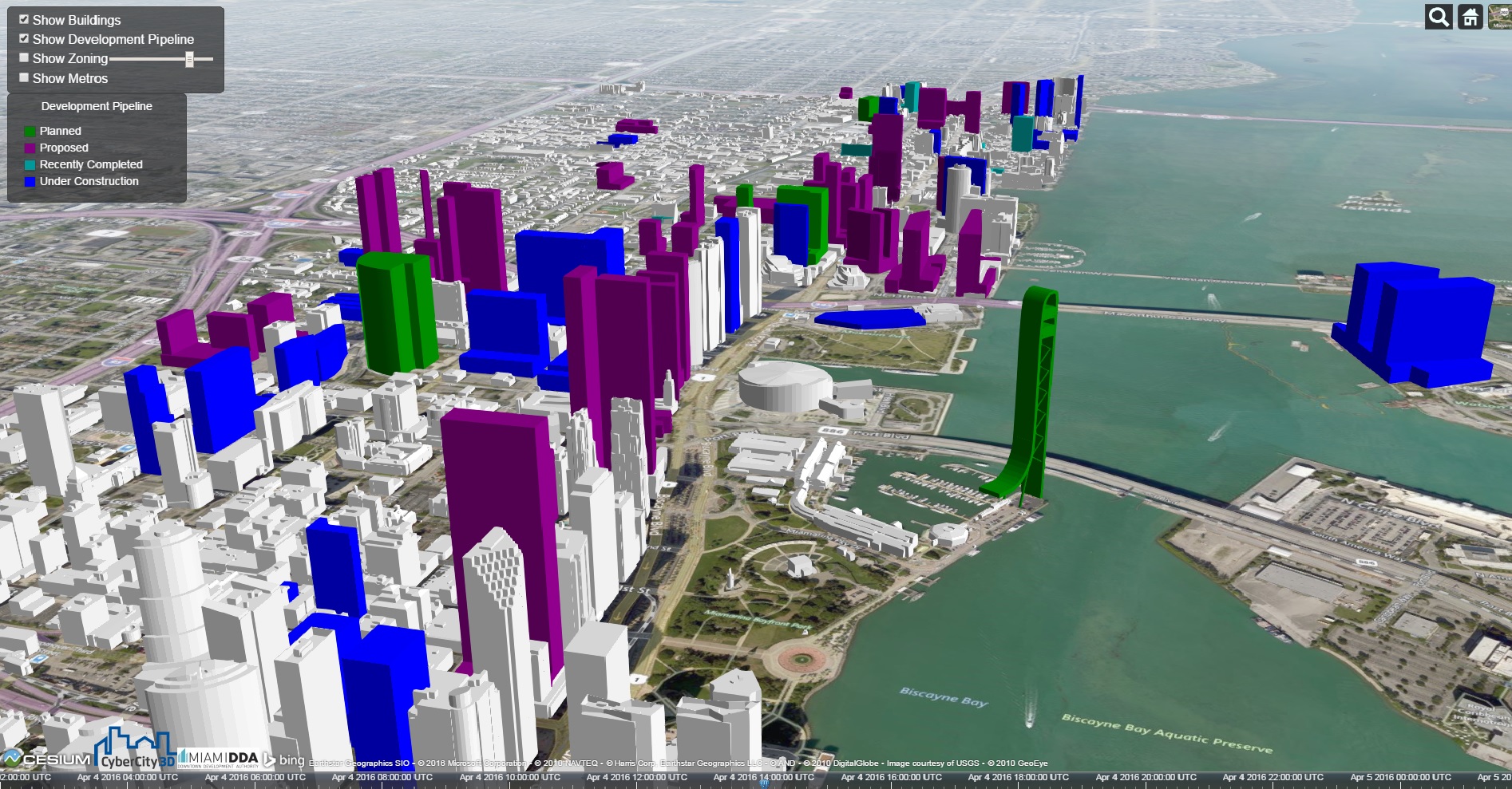 Miami's skyline after projects in development are completed. Click images to enlarge.
Related Stories
BIM and Information Technology | Apr 24, 2017
Reconciling design energy models with real world results
Clark Nexsen’s Brian Turner explores the benefits and challenges of energy modeling and discusses how design firms can implement standards for the highest possible accuracy.

BIM and Information Technology | Apr 17, 2017
BIM: What do owners want?
Now more than ever, owners are becoming extremely focused on leveraging BIM to deliver their projects.
Sustainable Design and Construction | Apr 5, 2017
A new app brings precision to designing a building for higher performance
PlanIt Impact's sustainability scoring is based on myriad government and research data.

BIM and Information Technology | Mar 28, 2017
Digital tools accelerated the design and renovation of one contractor’s new office building
One shortcut: sending shop drawings created from laser scans directly to a wood panel fabricator.
BIM and Information Technology | Mar 13, 2017
Real-time, high-speed scanning – The latest in reality capture
Here are a few new reality capture products and platforms that caught our eye.
BIM and Information Technology | Mar 10, 2017
'Reality modeling' arrives
Advanced reality capture technologies are breaking down the barriers between the job site and project models.

BIM and Information Technology | Feb 6, 2017
BIM for O+M: Less about the model, more about the data
How one Building Team is giving a university client what its facilities staff really wants from BIM: information, please.
Codes and Standards | Jan 13, 2017
New BIM guide for owners released
National Institute of Building Sciences releases a manual for developing standard set of BIM documents.

Designers | Jan 13, 2017
The mind’s eye: Five thoughts on cognitive neuroscience and designing spaces
Measuring how the human mind responds to buildings could improve design.

Architects | Oct 11, 2016
A good imagination and a pile of junk: How maker culture is influencing the way AEC firms solve problems
“Fail” is no longer a dirty four-letter word: for maker culture, it has become a crucial stop along the way


