


Miami is becoming more and more like New York, and that’s not just due to the migration between the two cities, or the influence that New York developers have in South Florida.
No, Miami is filling out its skyline. With more than 100 new hotel, residential, office, and retail towers and buildings in the development pipeline (projects that could be considered planned, proposed, under construction, or recently completed), the Miami Downtown Development Authority (DDA) launched a new interactive tool to keep track of it all.
The Downtown Miami Interactive 3-D Skyline Map displays depictions of current buildings and the buildings in development on a satellite terrain of downtown Miami and the adjacent Brickell neighborhood. Clicking on a building will bring up a window that tells the address, neighborhood, developer, status, and project description, which includes features, numbers of units, and dimensions and square footage.
Some of the most notable new developments include the Zaha Hadid-designed 1000 Museum, which is currently under construction; the hairpin-shaped Skyrise Miami entertainment and observation tower planned for the waterfront; the 4.9-acre Patricia & Phillip Frost Museum of Science that’s under construction; and the proposed One Bayfront Plaza, an 80-floor tower that will have 700 condos, 620 hotel rooms, and 650,000 sf of office space.
Users can adjust the times of day to see how sunlight and shadows hit buildings. The map also shows zoning boundaries and the routes of the Metrorail rapid transit system.
The DDA will update the map each quarter as buildings are completed and as new projects are announced. The organization has another 2D map that plots all of the projects in development.
Miami certainly has a lot of real estate activity going on. The Miami Herald, which reported in October that the downtown building boom would soon be ending, wrote in late March that the city was beginning a hotel boom. Four new hotels will be built downtown by 2018.
The Wall Street Journal, meanwhile, reported that Miami is on the verge of a condo bust as sales have slipped and inventory tanked. The leak this week of the Panama Papers, which revealed offshore financial dealings, will also hurt Miami’s luxury condo scene.
The Downtown Miami Interactive 3-D Skyline Map can be accessed here.
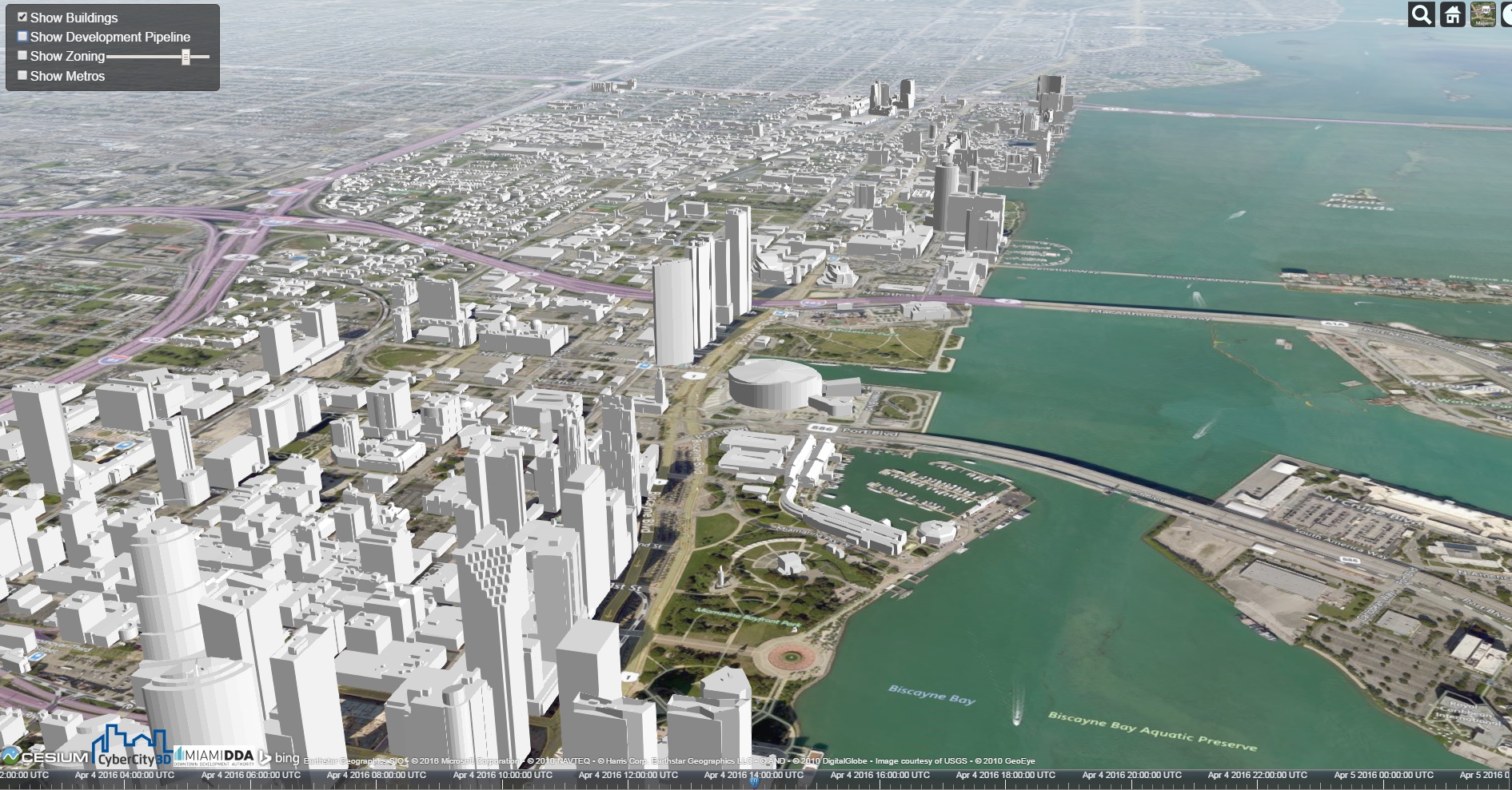 Miami's skyline in 2016.
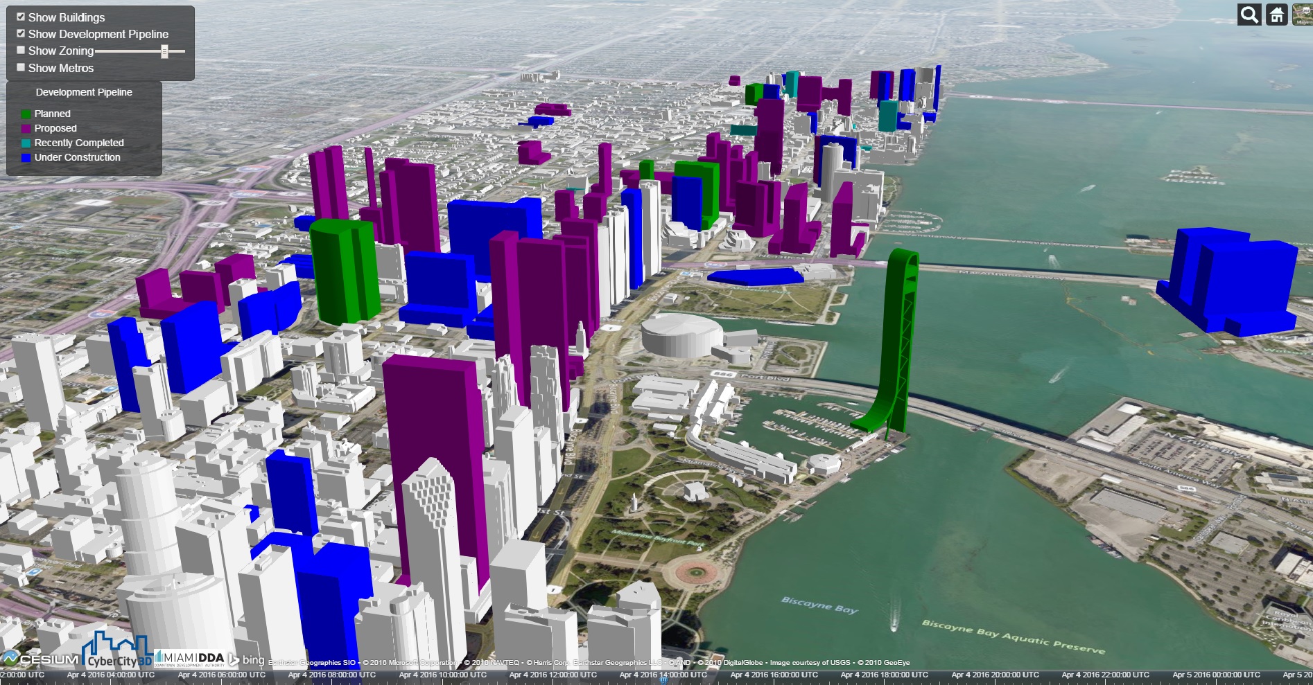 Miami's skyline after projects in development are completed. Click images to enlarge.
Related Stories
BIM and Information Technology | Jul 25, 2016
Autodesk’s LIVE turns designs into video game-like experiences
Users can adjust navigation points, render styles, and even the time of day, with fluid and quick controls.

Building Tech | Jul 14, 2016
Delegates attending political conventions shouldn’t need to ask ‘Can you hear me now?’
Each venue is equipped with DAS technology that extends the building’s wireless coverage.

BIM and Information Technology | Jun 14, 2016
Autodesk and Trimble will share APIs to develop products that improve user workflow
Data and document management is likely to benefit the soonest.

BIM and Information Technology | Jun 13, 2016
The race to digitize the globe with 3D imagery
Tech firms are creating a highly-detailed virtual planet available instantly for those who would like to scrutinize it. SmithGroupJJR's Stephen Conschafter details the new technologies being used to map our world.

BIM and Information Technology | Jun 7, 2016
Conquer computational design: 5 tips for starting your journey
Data-driven design expert Nathan Miller offers helpful advice for getting your firm ready to use CD tools and concepts.

BIM and Information Technology | Jun 7, 2016
6 ways smart AEC firms are using computational design methods
Rapid prototyping, custom plug-ins, and data dashboards are among the common applications for computational design.

BIM and Information Technology | May 20, 2016
AIA and Autodesk introduce new feature to automate 2030 Commitment reporting data
The new automated connection will allow the more than 350 AIA 2030 committed firms to report their project and portfolio performance to the DDx directly from Autodesk Insight 360.

AEC Tech | May 10, 2016
Thornton Tomasetti launches new tech company
TTWiiN initially features six products and will add more via its own incubator.

Sponsored | BIM and Information Technology | May 10, 2016
Advanced laser scanning technology supports data collection and modeling efforts for Missouri’s Iatan 1 Power Plant
For the installation of a new heat exchanger, the power division of Black & Veatch contracted an engineering firm to laser scan the site, make a piping model in Autodesk® Revit®, and export it into AutoCAD® to deliver results.

AEC Tech | May 9, 2016
Is the nation’s grand tech boom really an innovation funk?
Despite popular belief, the country is not in a great age of technological and digital innovation, at least when compared to the last great innovation era (1870-1970).


