A laser scanning solution for challenging topographic surveys

When a large Southern California municipality required detailed surveys for the installation of solar energy collection panels in corporation yards and facility rooftops, they partnered with one of the largest global renewable energy development companies, who in turn, engaged the creative and innovative services of DeWalt Corporation to provide surveying solutions for some challenging sites.
The Job and Its Challenges
The Southern California City recently partnered with an international renewable energy company to install solar-covered parking and solar roof panels on over a dozen different sites throughout the city’s greater area, including corporation yards and facilities, parks, libraries, and police and fire station roofs.
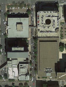
DeWalt Corporation was called upon to complete the topographic surveys on these sites. Nineteen included underground utility location and eight included rooftop surveys. Some sites were straightforward and were shot entirely with GPS and conventional survey methods. However, there were some sites with access restrictions, in particular, two buildings in the heart of the city, which are surrounded by trees, heavy traffic, construction equipment, and are encircled by other buildings that are taller than most, creating a challenge for the team.
In general, a surveyor can only shoot one point at a time, and this point needs to have attributed data attached to it in order for the information to have any value while drafting. In particular, topographic and ALTA surveys can require up to a few thousand points to be shot, not to mention dozens of codes. Further complicating the matter is the break in workflow from surveyor to drafter. What may appear to be common sense to the person capturing the data may come across as nonsensical to the drafter. Add this to the fact that every client may ask for slight variations in what is captured and documented, the survey company is then faced with the potential to miss important shots or incorrectly identify assets.
The Solution
DeWalt Corporation, which has completed thousands of surveys over the last 50 years, began using 3D laser scanning technology nearly five years ago. At first scanning was offered as a product and service all on its own. We have now moved from a service-based product, to a solutions-based product, which entails using everything we have in our arsenal to streamline and enhance what it is we can offer to clients. For this job, DeWalt utilized a 3D laser scanning solution to get the job done.
In the past two years, DeWalt has been working toward using our laser scanner as a survey tool. A typical job would require our surveyors to capture the necessary points using some combination of the conventional total station and our GPS systems; however, this particular site would be different. While our surveyors are experienced, highly talented individuals, the work, nonetheless, had its issues. For reconnaissance, we first used Google Earth images (aerial and street view) in order to get a basic idea of what the sites looked like. We were able to identify buildings and trees that could interrupt direct sunlight to solar panel preliminary locations. It should be noted that this reconnaissance led DeWalt to believe that using 3D laser scanning for some of the survey work would be advantageous, cost and time effective, and could provide a clearer picture of the topography and above-ground improvements.
In order to capture the full complexity and details of the building, its roof and surroundings 25-feet out, DeWalt used the FARO Focus3D X 330 Laser Scanner to gather all the data and virtually bring the select portion of downtown to the drafters. In short, the scanner takes up to 1 million readings every second. Every reading yields one point of data, and this data is from a surface that was directly visible to the scanner. With enough points taken, we were able to capture the entire site and recreate the scoped area in a dimensionally accurate, full color, and highly detailed point cloud.
Unfortunately, a large number of laser scanning practitioners believe that the skill lies in the actual scanning process. While this was once the case, it is no longer true. Improvements in technology have made the actual scanning itself very simple and straightforward, lending itself to greater accuracy.
True expertise now lies in knowing how to use the data to deliver what the client needs. In using our Focus3D X 330 as a survey tool we were faced with two obstacles, both of which were easily solved. The first was achieving survey grade-accuracies in the point cloud and attaching the data to the chosen coordinate system, and the second was being able to easily draft from the point cloud.
For tackling the first problem, we still needed some form of traditional surveying. As mentioned above, all of the sites typically would have started with GPS surveying. This wasn’t an option, though, as the location placed us adjacent to tall high-rise structures, effectively cutting the number of satellites from fifteen or sixteen, down to two. Instead, local control network was established by tying into monument markers using the total station; we tied directly into the boundary and carried this control directly into our scans. This boundary is what tied the surveying down to a known coordinate system. In a traditional topographic survey we would use GPS and conventional tools to record everything from utility location markings to curb, gutter, paint lines, and all other topographic features. Instead, we used the laser scanner to capture the topography, which in turn would be tagged and labeled by our drafters.

Using the total station, we set points by recording the centers on a series of checkerboard targets set throughout the site. These checkerboard targets are easily identified in the scans and the center of each has a known Cartesian value that is a part of the established coordinate system. By using traditional survey to bring the coordinate system in, we were able to accurately place each and every scan exactly where it lies on the face of the earth. Our surveyor simply planned his course, making sure that each scan had adequate overlap onto the next scan and that the perspective of the scanner was established to completely capture our scoped area.
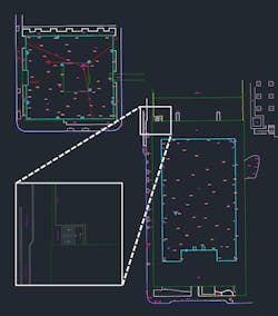
Upon returning to the office, the survey and scan files were off-loaded in the same way a surveyor would deliver his point files (only the scans are considerably larger). From here the scans had to be registered to create the point cloud that was used for the drafting. First, the scans were registered in SCENE using the cloud-to-cloud function, This method uses the shared points from one scan to the next and identifies where one scan resides in relation to another. Once the entire cloud was registered tightly to itself, it was placed on the coordinate system. The previously identified checkerboard targets that were shot using the total station were each assigned their respective values by importing the surveyor’s control file. This finalized the registration by placing the entire cloud on the control network. By using this proven method, we were able to parlay a relatively simple survey boundary into millions of data points, each with real dimension and real RGB color.
From here, and while still in SCENE, we were able to draft directly into AutoCAD Civil 3D. Using the DrawToAutoCAD add-on in SCENE, we able to use the 360° perspective of the scanner, known as the planar view, to identify all necessary assets. Opening either a new or existing drawing in Civil 3D, and while the planar view is open in SCENE, the command is started in Civil 3D, and the points are selected in the planar view. When the adequate number of points were all selected for the given command, the operation ends. In the case of continuous commands, such as a polyline, the command is terminated the standard way in the model space.
Trees became much easier to record. A click at the base of the trunk and a few more clicks on the crown allowed the height, diameter, and location of the trees to be captured. Intricate building corners and faces, complex curbing, features from the middle of a busy road could all be captured using simple clicks in the registration software.

The Results
Our team realized multiple benefits from using the laser scanner on this project.
Safety: DeWalt values safety above all else. On any given job, we need to capture manhole lids, road striping, and any other asset that may reside in a difficult or unsafe place to reach. Safety was particularly important on this job, which was smack in the middle of downtown. We had to contend with heavy traffic, various concurrent operations related to construction, road projects, and other types of roadwork, which made for complicated surveying. By implementing the use of a tool that could capture the necessary information at a distance, we were able to keep everyone involved immeasurably safer.
Time Cost: By scanning to collect the topographic data, we are not removing the cost of the employee but we are able to capture millions of points of data with every scan. Each scan takes approximately six minutes using the right settings, in which time a surveyor can capture a strip of sidewalk, building corners, or some paint striping as well as everything it sees in a 1,000ft. radius. Assuming everything is flat (which it never is), this is over 3,000,000 sq. ft. of area. Even if we clip the data back to around 100ft. to achieve a higher level of clarity, this still comes in at over 30,000 sq. ft. For those jobs where we need to replace a couple of thousand survey points or that has an obstructed horizon, laser scanning becomes a leading survey option. For this site, some spots along our path had forced mask angles of 80° or more. This required all traditional survey to be done using the total station, a more time consuming process. Had we not been able to scan the site, our field time would have increased by 50 percent. By capturing everything, and doing it at a consistent rate, the number of items to be included became irrelevant to our field time. We simply captured the site and allowed the drafter to document what was needed.
Economic Benefits: Scanning allows fieldwork to move along quickly, and on short-order jobs such as this one, lost time can quickly translate into lost revenue. While scanning may not be the answer for every survey project, we carefully select the jobs that can effectively implement scanning as a survey tool. Factors to include are the above-mentioned safety and time considerations as well as financial factors. This project was prevailing wage for all of our fieldwork. As was addressed above, shooting everything conventionally would have increased our time by 50 percent. Our drafters would still have to take the data captured, regardless of method, and generate the drawings, so there is little difference in the money saved for drafting. But being able to pass on a savings of 33 percent to our client when such a high billing rate is mandated allows us to see laser scanning as a responsible and advantageous choice. Prudence in knowing when to scan and when not hones and magnifies these financial benefits.
Complete Reality Capture: By scanning a site for topographic work, you not only get more data, you get all the data so you don’t have to go back and repeat the work. If a drafter is concerned with the coding or placement of a certain shot, he or she is now able to just step into reality and see firsthand what was where. By scanning there are no missed shots, and no shortage of data. Should we receive a change order that requires us to record a new feature or asset, we simply reopen the point cloud and draft. As long as the request does not increase the area in which we are to survey, there is no need for a return trip.
For more information on DeWalt Corporation, please click here.