


By definition, a city is a big place. And, as such, it is hard to stay on top of everything going on within its borders. There will always be outcomes to scenarios that couldn’t have been predicted, issues that arise from small details overlooked in the planning process.
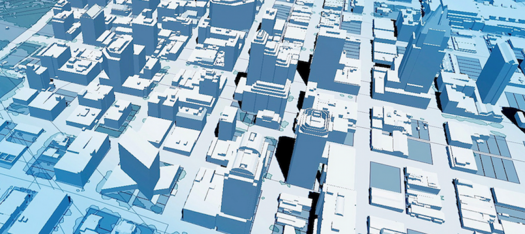
But the city-state of Singapore is trying to rectify this issue and make sure no small details are overlooked again. What is their solution? To create a hyper-realistic virtual model of the island city-state, something they are currently in the process of doing.
With the help of the Prime Minister’s Office and Dassault Systèmes, a multinational software company that is at the forefront of 3D design, Virtual Singapore is well on its way to completion.
Virtual Singapore will incorporate information such as data about the climate, demographics, energy consumption, and building elevation, all the way down to small details like the location of trees.
If you ever played SimCity, a game designed by legendary game designer Will Wright, this probably seems pretty familiar to you. But Virtual Singapore is built for more than just entertainment.
“You can click on a building and see the surface of its roof, how much electricity it consumes. You can simulate how in the event of a gas leak or a bombing, the population could escape based on where people are,” said CEO of Dassault Systèmes, Bernard Charlès, in an interview with Tech Insider. “We have simulation engines for this.”
Virtual Singapore can be used for more than planning for emergencies or disasters, though. It can also be used to see how a proposed change to the city would affect it. Thus, helping to eliminate those tiny overlooked details that rear their ugly heads later on in the process, when issues become more expensive to fix.
The majority of the data being used to create Virtual Singapore was stored on siloed platforms, but Charlès hopes to eventually incorporate data directly from citizens, such as information from cars or fitness trackers.
Dassault Systèmes projects Virtual Singapore to be completed by 2018.
Related Stories

Building Technology | Oct 7, 2016
How much is that LEED point worth? A new tool provides answers
Autocase analyzes the financial, social, and environmental benefits of certification.

Sponsored | BIM and Information Technology | Oct 3, 2016
A laser scanning solution for challenging topographic surveys
DeWalt Corporation, which has completed thousands of surveys over the last 50 years, began using 3D laser scanning technology nearly five years ago.

BIM and Information Technology | Sep 15, 2016
8 tips for perfecting co-location
Experts share tips and tricks for maximizing cross-team collaboration.
BIM and Information Technology | Sep 12, 2016
Draft of 2016 version of the LOD Specification has been released for public comment
The comment period is open until Sept. 23.

BIM and Information Technology | Sep 7, 2016
Energy Star Portfolio Manager tool updated to factor in waste management
The costs and benefits of managing 29 types of waste are now included.
BIM and Information Technology | Aug 30, 2016
BIM GIANTS: A ranking of the nation's top BIM design and construction firms
HOK, Perkins+Will, Turner Construction Co., The Whiting-Turner Contracting Co., Jacobs, and Thornton Tomasetti top Building Design+Construction’s annual ranking of the nation’s largest BIM AEC firms, as reported in the 2016 Giants 300 Report.

BIM and Information Technology | Aug 30, 2016
New service from CBRE provides deeper insights into in-building wireless network experiences
With dependable cellular and Wi-Fi coverage a must-have amenity for today’s businesses, CBRE to certify in-building network quality through new Cellular Signal Mapping service

BIM and Information Technology | Aug 22, 2016
The wicked problem of interoperability
Building professionals are often put in a situation where solving problems with the ‘best tool for the job’ comes at the cost of not being able to fully leverage data downstream without limitation, writes Proving Ground's Nathan Miller.

Contractors | Aug 10, 2016
Dodge launches new app to simplify pros' search for suitable projects to bid and work on
The product, called PlanRoom, could be particularly useful in sharing data and communications among AEC teams.

BIM and Information Technology | Aug 9, 2016
How to improve a project presentation with animated GIFs
Animated GIFs are a simple tool that can explain a large amount of intricate information in an easy to understand, streamlined manner.


