

Has “reality modeling” gone mainstream? Greg Bentley, CEO of Bentley Systems, thinks so. Speaking at the Year in Infrastructure Conference in London last November, Bentley presented his case that more projects are benefiting from geometrically accurate 3D models created by stitching together captured images using software like his company’s ContextCapture.
“I believe we will go on to see reality modeling answering the question as to how drones, mixed reality devices, the industrial Internet of Things—and, in fact, ‘digital natives’—will converge to advance infrastructure engineers, project delivery, and asset performance,” Bentley stated.
His vision would not sound farfetched to AEC firms that view reality capture as important to their designs, construction, and marketing.
“How you deliver projects is fundamentally changing, and it’s shifting how we interact with clients,” says Jason Rostar, Corporate Design Technology Leader with Harley Ellis Devereaux. “You don’t need an Oculus Rift to immerse your client anymore. It can be done with a cellphone or Google cardboard.”
In January, Gilbane Building Company hosted an internal webinar on innovation that focused on reality capture. “We’re finding that there is more of a need to visualize for field purposes,” explained Sue Klawans, the firm’s SVP and Director of Operational Excellence and Planning. Reality capture, she said, “helps us see the ‘value added’ in a project.”
When officials at Penn State University expressed concerns about the materials and configuration of a rock-climbing wall being installed in an intramural facility on campus, the project’s GC, Mortenson Construction, turned to virtual reality to work through solutions. The firm used IrisVR, which leverages game-engine technology, to give the client the sensation of scaling the wall. That experience helped Penn State select the building products used. “The discussion evolved into how the facility would function,” says Taylor Cupp, LEED AP BD+C, Mortenson’s Project Solutions Technologist. “That’s a conversation we weren’t having before.”
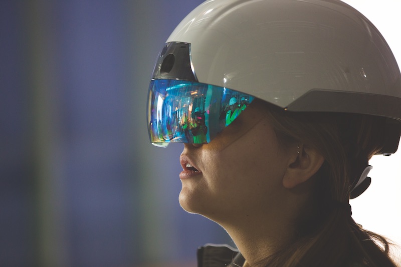 Last November, Mortenson Construction and Daqri conducted a test at a hospital under construction in Minneapolis, where Mortenson downloaded planned work in augmented form into Daqri helmets to let engineers visualize how materials and components would be installed. Courtesy Daqri.
It Starts with Laser Scanning
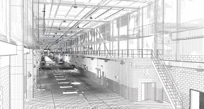
Many AEC firms enter the reality-capture realm via laser scanning. PCL Construction now uses laser scanners “in every district and on nearly every project,” says Nick Kurth, PCL’s Virtual Construction Manager in Denver. In the previous 18 months, his firm had purchased a dozen scanners, and now has at least two employees in each district who can use this equipment.
PCL deploys scanners primarily to capture projects’ existing conditions and as-built progress. It has also begun testing hand-held scanners, which Kurth suggests might be best suited for remodeling or reconstruction projects. “We’re looking for scalable solutions,” he says.
Over the past year, the use of laser scanning “has exploded” at Skanska, which now scans most renovation and restoration projects. “It’s a great way to interface with the owner and architect, and give them a sense of what’s really out there,” says Tony Colonna, SVP of Innovative Construction Solutions with Skanska.
He believes reality capture will continue to be a critical component for creating “mixed reality representations” from data collected by drone cameras and scanners that can be embedded into a 3D model and compared with original documents.
Colonna points to Skanska’s use of drone footage overlaid with BIM modeling and advanced visualization tools to help its project team understand design options and simulate scheduling sequences for the upcoming construction of a new 129,000-sf ice rink for a high school in Massachusetts, which will replace an existing facility whose lockers, wrestling room, and circulation spaces will be renovated.
The common thread connecting these and other examples of reality capture is that AEC firms are searching for ways to get more and better information into the hands of their field workers quicker. As the website Uploadvr.com put it recently: “Ultimately, construction professionals want a scan so accurate that workers can walk through spaces with an AR headset and view the BIM model on top of it.”
Reality capture “changes the conversation about redesigning existing spaces,” says Kapil Khanna, Director of Design and Construction with Clayco’s Forum Studio. He adds that reality capture provides reliable data from which project teams can make “upfront decisions” in real time.
The mobility of reality capture tools is becoming a game changer. Mortenson recently completed a test with Daqri—best known for its “smart” work helmets—where it downloaded planned work for a medical project in augmented form into helmets to allow engineers to visualize how certain materials and components would be installed.
“This also allowed them to theorize how the building would be laid out,” says Cupp. He sees AR and MR tools like Daqri and Microsoft’s HoloLens as “real breakthroughs. Now we’re waiting for people to connect the dots.”
The industry’s trajectory in that direction seems inexorable. Last June, Microsoft joined forces with Trimble and AECOM to use HoloLens for displaying holographic displays of BIM models, project team collaboration, and immersion in construction plans. Two months later, a noteworthy proof of concept test, conducted by drywall contractor Martin Brothers and Scope AR, demonstrated how it was possible to construct a bathroom pod in a controlled environment with only an augmented 3D model showing where each piece should be placed.
PCL has been working with Context VR, a project management mobile app, on two high-rise buildings in Seattle. According to the Daily Journal of Commerce, users upload drawings and floor plans as PDFs, and walk through the buildings taking 360-degree photos that interface with mobile devices to store images on the cloud. The end product can be displayed via a VR viewer.
Kurth says that PCL is using 360-degree cameras more frequently of late, especially for condo projects. “With all of the electrical and fiber that gets run through those buildings, it’s a challenge to go in every week and take photos [for progress reports]. Using a 360 camera saves a lot of time.”
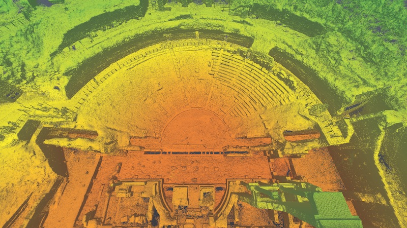 Over two weeks last fall, Autodesk, Case Technologies, and Volterra-Detroit Foundation 3D-scanned key historical and archeological sites in Volterra, Italy, to assist in that town’s preservation efforts. This image is an elevation scan of Teatro Romano, an ancient open amphitheater. All told, the team generated 350 scans. Courtesy of Autodesk.
Users want tools that mesh
The pervasiveness of reality capture for construction inevitably has led to a blizzard of products and platforms saturating the market. How firms choose among different hardware and software tools often comes down to how well the tools work together.
Cupp, for one, is waiting for a platform that can move data from Navisworks to VR smoothly. Dave Burns, Director of Field Systems with McCarthy Building Cos. in San Francisco, notes that some software packages, especially cloud-based tools, are still “closed-off systems.”
“The first thing a customer must ask is how well a platform wrestles with the data being produced from all kinds of sources, and how well it transports and processes these data over the Internet,” says Skanska's Colonna. His firm is using or exploring three scanning platforms: Autodesk ReCap, Faro Scene, and Edgewise.
PCL favors BIM 360 Field to interconnect and coordinate all that it’s capturing. “We can pull points out of a Revit model without having to do a lot of additional CAD work,” says Kurth.
Gilbane’s VDC team is part of its leadership group that meets monthly to discuss pilots and solutions. These meetings, says Klawans, keep the company’s reality capture goals on track.
When asked about overcoming concerns about interoperability, Klawans cites BIM 360 Glue, a cloud-based BIM software that connects project teams and streamlines BIM workflows from preconstruction to execution. “We can’t afford to be burdening architects with getting things into one system,” he says.
Cost always comes into play when choosing products. McCarthy has had success with Matterport, which captures properties in interactive 3D imagery, to document unique and complex facilities and turn that information around for business development and marketing. Ryan Moret, McCarthy’s Field Solutions Manager in Dallas, describes Matterport as the “middle ground” between using an expensive laser scanner and a $3,500 camera, “with a slightly lower learning curve and a high-quality deliverable.”
Thomas Schander, CEO and Co-founder of Enscape, the visualization software provider, says that a lot of newer reality capture products come out of the gaming industry. But gaming is usually “precomputed,” whereas AEC firms want to make instantaneous changes. “Architecture is demanding,” which is why Enscape has developed its own rendering technology.
As there are no real BIM standards, Schander isn’t holding his breath in anticipation of standardization in reality capture. “The best that companies like ours can do is to support as many platforms as possible,” he says.
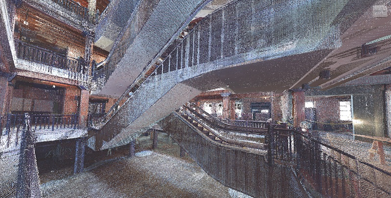 Laser scan of an escalator system at Granite Properties’ Factory Six03, a historic restoration project that DPR Construction is currently working on in Dallas. Courtesy DPR Construction.
Creating amid the chaos
With technology changing so rapidly, it’s hard to predict what’s next for reality capture. “There’s a lot of theory out there,” says Clayco's Khanna. “But what’s exciting is the dialogue that’s taking place, which is almost as important as coming up with the answers.”
Keeping up with the Joneses, though, promises to be a full-time job for firms that want to stay on the leading edge of reality capture. “Technology is one of those things that you don’t want to lose a project over,” says Kurth of PCL.
Related Stories
Building Technology | Oct 7, 2016
How much is that LEED point worth? A new tool provides answers
Autocase analyzes the financial, social, and environmental benefits of certification.
Sponsored | BIM and Information Technology | Oct 3, 2016
A laser scanning solution for challenging topographic surveys
DeWalt Corporation, which has completed thousands of surveys over the last 50 years, began using 3D laser scanning technology nearly five years ago.
BIM and Information Technology | Sep 15, 2016
8 tips for perfecting co-location
Experts share tips and tricks for maximizing cross-team collaboration.
BIM and Information Technology | Sep 12, 2016
Draft of 2016 version of the LOD Specification has been released for public comment
The comment period is open until Sept. 23.

BIM and Information Technology | Sep 7, 2016
Energy Star Portfolio Manager tool updated to factor in waste management
The costs and benefits of managing 29 types of waste are now included.
BIM and Information Technology | Aug 30, 2016
BIM GIANTS: A ranking of the nation's top BIM design and construction firms
HOK, Perkins+Will, Turner Construction Co., The Whiting-Turner Contracting Co., Jacobs, and Thornton Tomasetti top Building Design+Construction’s annual ranking of the nation’s largest BIM AEC firms, as reported in the 2016 Giants 300 Report.

BIM and Information Technology | Aug 30, 2016
New service from CBRE provides deeper insights into in-building wireless network experiences
With dependable cellular and Wi-Fi coverage a must-have amenity for today’s businesses, CBRE to certify in-building network quality through new Cellular Signal Mapping service
BIM and Information Technology | Aug 22, 2016
The wicked problem of interoperability
Building professionals are often put in a situation where solving problems with the ‘best tool for the job’ comes at the cost of not being able to fully leverage data downstream without limitation, writes Proving Ground's Nathan Miller.
Contractors | Aug 10, 2016
Dodge launches new app to simplify pros' search for suitable projects to bid and work on
The product, called PlanRoom, could be particularly useful in sharing data and communications among AEC teams.
BIM and Information Technology | Aug 9, 2016
How to improve a project presentation with animated GIFs
Animated GIFs are a simple tool that can explain a large amount of intricate information in an easy to understand, streamlined manner.


