

DPR Construction tries to resist being driven by the technology of the moment, says Chris Torres, the firm’s Technology Integration Manager.
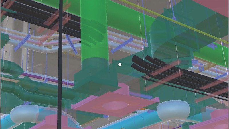
But there are times, he admits, when attention must be paid. That happened last November, when Torres got his first glimpse of Indoor Reality, a backpack with a built-in laser scanner that its creators claim can scan 200,000 sf in just eight hours—roughly 30 times faster than stationary scanners.
The product—one of several similar backpacks on the market—goes wherever the user roams, using cellphone-based indoor GPS as its guide. The manufacturer claims the unit can help project teams generate Revit models three times faster than traditional point cloud methods.
Indoor Reality’s $100,000 price tag might be prohibitive for some AEC firms, but Torres says the supplier also showed a hand-held version that goes for around $15,000.
The reality capture world is replete with new products; so many, in fact, that it’s a wonder buyers can keep up with the releases. Here are a few new products and platforms that caught our eye:
- RTK and PPK. These are acronyms for real-time kinematic and post-processing kinematic GPS sensors. They are part of systems that provide accurate camera locations when using drones for mapping. They reduce the need for surveyed ground control to produce accurate digital terrain models and orthophotos from photogrammetry. PPK doesn’t require a radio link. Accuracies of 25 mm (XY coordinate) and 50 mm (Z coordinate) are achievable.
- A host of hand-held laser scanners has been making its way onto the market. One that’s been getting attention from AEC experts is Leico Geosystems’ BLK 360 scanner. Size: 6.5 inches by 4 inches. Weight: 2.2 pounds. It is capable of 360-degree spherical imaging, thermal imaging, and full 360-degree reality capture in less than three minutes. Price: under $16,000.
- SLAM, which stands for simultaneous localization and mapping, lets construction workers walk through a project site and map it in extreme detail in minutes. SLAM scans in real time and doesn’t require GPS. One company in this arena, GeoSLAM, recently launched Desktop V3, which incorporates a 2D and 3D viewer so registered point clouds can be viewed without moving to third-party software.
- Product tie-ins are the rage these days. Enscape, which provides visualization software for architects, just released a real-time rendering plug-in for Revit. Early adopters include Kohn Pedersen Fox and Foster+Partners. “What’s important,” says Thomas Schander, Enscape’s CEO, “is that now you don’t need to be a rendering expert to create stunning presentations.”
Related Stories

BIM and Information Technology | Nov 18, 2015
AIA: Energy modeling key to reaching carbon neutrality in buildings
Energy modeling allows architects to be more ambitious with energy-saving in their design projects.

Green | Nov 17, 2015
DOE launches new data collaborative to help cities and states boost building efficiency
The SEED Standard will help manage, standardize, share performance data.

Sponsored | BIM and Information Technology | Nov 12, 2015
Is the PDF revolution advancing BIM workflows?
Many project teams who struggle to get everyone up to speed with BIM, find PDFs a useful tool to bridge the gap between the BIM world and the paper world

BIM and Information Technology | Nov 3, 2015
How virtual and augmented reality can shape architecture and design
Gensler's Alan Robles examines a few ways VR and AR could create value for architecture and design professionals.

BIM and Information Technology | Oct 29, 2015
MIT develops ‘river of 3D pixels’ to assemble objects
The Kinetic Blocks can manipulate objects into shapes without human interference.

BIM and Information Technology | Oct 27, 2015
Magic Leap's breakthrough augmented reality project continues to generate support
The company is developing the Dynamic Digitized Lightfield Signal. It projects images onto the retina, giving users an interactive 3D experience.
BIM and Information Technology | Oct 26, 2015
Tableau’s new app, Vizable, converts spreadsheets into charts and graphs
Everyday users can simplify large amounts of data and sift through it interactively.

Architects | Oct 20, 2015
Four building material innovations from the Chicago Architecture Biennial
From lightweight wooden pallets to the largest lengths of CLT-slabs that can be shipped across North America

BIM and Information Technology | Oct 19, 2015
A robotic arm can 3D print, etch, solder, and carve from a desktop
It’s not just a 3D printer. The creators say Makerarm can also etch, solder, and put icing on cake.

BIM and Information Technology | Oct 19, 2015
New web tool from MIT organizes human movement in interactive graphs
Users can explore the mobile phone activities in London, New York, Los Angeles, and Hong Kong.


