

Over the years, Pepper Construction, like most general contractors, has hit its share of underground utilities installed beneath jobsites. “That’s not a phone call the CEO of our company wants to get,” says Mike Alder, Virtual Construction Manager at Pepper’s office in Indianapolis.
These breaches have occurred despite standards and protocols that have been in place for decades to identify and avoid underground pipes, wiring, and cables. Pepper typically hires a public or private locating company—depending on who owns the land—that relies on a combination of schematics on record, what’s visible above ground, and what’s underground that can be tracked by certain equipment. Sometimes, excavation is required.
But a few years ago, Pepper started asking itself whether there was a better way to locate and avoid hitting utilities. This is particularly important for hospital projects, says Alder, “where you don’t want to disrupt service and what might be on the other side of that service.”
In conversations with its field crews and subs, Pepper heard over and over again that the lack of communication and subpar information were the culprits behind these collisions. “We walked out of those meetings with the notion that everyone had a victim mentality,” says Alder.
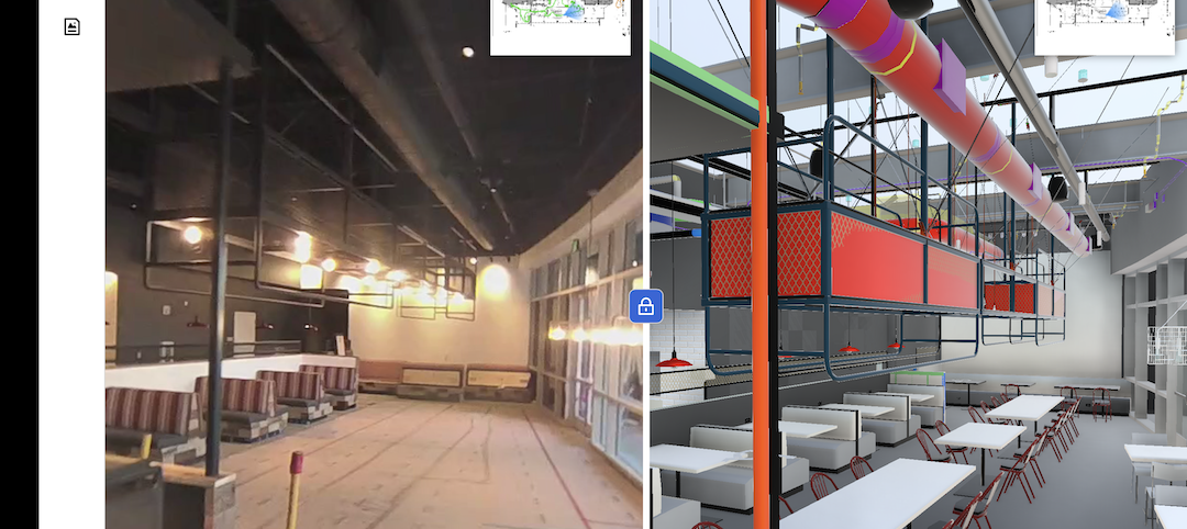
At one of those meetings, Pepper’s safety director, Dave Murphy, made what Alder recalls as an “obvious but profound” observation that “we hit underground utilities because we can’t see them.” Soon after, in 2017, Murphy and Alder started working together to create underground 3D models. “Civil drawings just weren’t enough anymore,” says Alder.
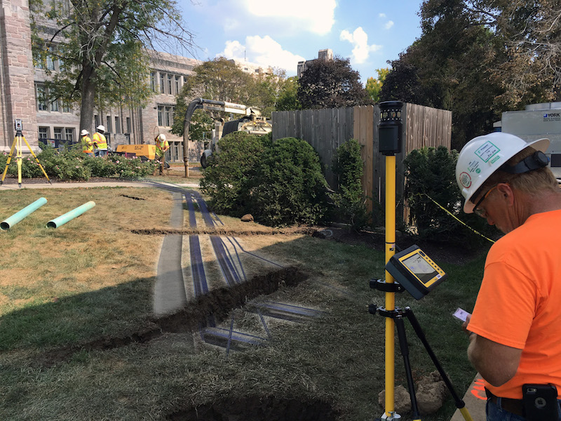
Their first step was to gather site drawings, and then overlay them with the new utilities and building that were being installed. Using those images as guides, Pepper then went to the site with a Vac truck, which Alder describes as a giant dirt vacuum, to further locate the buried utilities and to mark them by putting six-inch pipes into the ground.
Pepper had been doing all of this before. But now, it was also surveying the site, and bringing those survey points into modeling software. Alder says his company also creates 3D models for the project’s new utilities. “The benefit of this is that we were finding places where there were clashes between the old and new utilities.”
Pepper shares this information with its field crews, giving them better reconnaissance.
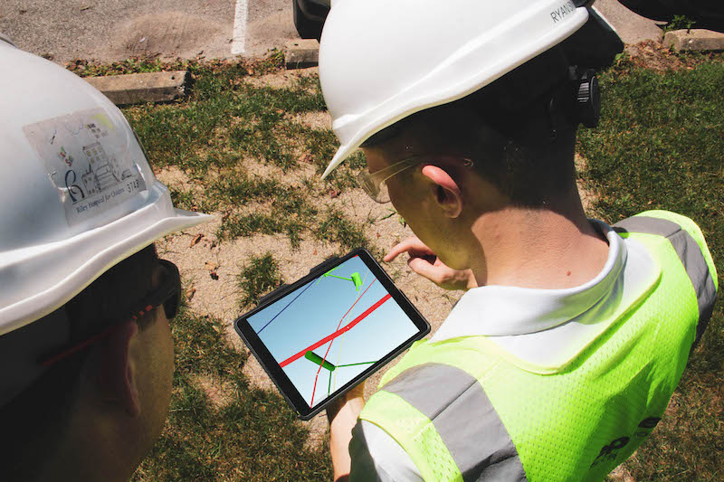 Crew members look at models showing where underground utlities are located on jobsites. Image: Pepper Construction.
The firm has done underground 3D models for more than a dozen projects, and over time has made some tweaks to its process. For one thing, it’s been trying to get Civil Engineers on projects more involved upfront in the drawings and surveying during the design phase.
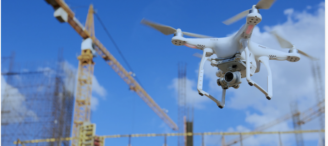
Pepper also flies drones over its jobsites to capture imagery that can be used to create 2D maps of the site, which Alder says gives the underground 3D models more perspective.
The modeling of underground utilities is now standard operating procedure for Pepper’s Indiana office. (Alder couldn’t say whether the firm’s other offices were following suit.). “If we had waited for the process to be perfect, we probably wouldn’t have rolled this out yet.”
Pepper is looking attempting to leveraging technology to create better models faster, and to produce a more dynamic deliverable, which will mean getting crews in the field more involved in up-to-the-minute the data collection.
“It’s important to realize that this has been a big endeavor for us,” says Alder. “It’s like flipping the industry on its head.” He notes, though, that the biggest obstacle to more widespread underground 3D modeling continues to be the cost it adds to the project, and the potential for adding more time, too, if it’s not scheduled properly.
Related Stories
AEC Tech | Mar 10, 2020
No labor. No infrastructure. No problem.
OpenSpace’s AI-based reality capture tool looks to make site documentation a completely passive experience.

Healthcare Facilities | Mar 9, 2020
Mobile wayfinding platform helps patients, visitors navigate convoluted health campuses
Gozio Health uses a robot to roam hospital campuses to capture data and create detailed maps of the building spaces and campus.

Green | Mar 9, 2020
BuroHappold commits to all new building projects achieving net-zero carbon by 2030
The engineering firm also launched a long-term partnership with ILFI.

Architects | Mar 2, 2020
Two ‘firsts’ for Sasaki and LEO A DALY
Following an industry trend, the firms hire chiefs of technology and sustainability, respectively.

AEC Tech | Feb 22, 2020
Investor interest in the built environment not quite as avid in 2019
Builtworlds’ annual list of venture deals led by workspace providers.

AEC Tech | Feb 13, 2020
Exclusive research: Download the final report for BD+C's Giants 300 Technology and Innovation Study
This survey of 130 of the nation's largest architecture, engineering, and construction firms tracks the state of AEC technology adoption and innovation initiatives at the AEC Giants.

AEC Tech | Feb 5, 2020
BIM London: A glimpse of BIM discussions across the pond
Digital twin, ISO standards, blockchain, and data were the hot topics at the recent The Digital World: BIM event.
AEC Tech | Jan 16, 2020
EC firms with a clear ‘digital roadmap’ should excel in 2020
Deloitte, in new report, lays out a risk mitigation strategy that relies on tech.

Green | Jan 10, 2020
How the new EC3 tool raises the bar on collective action
Nearly 50 AEC industry organizations partnered to develop the groundbreaking Embodied Carbon in Construction Calculator.
AEC Tech | Jan 8, 2020
Thornton Tomasetti launches open-source embodied carbon measurement tool
Beacon is a Revit plugin that generates a comprehensive data visualization of a project’s embodied carbon.


