

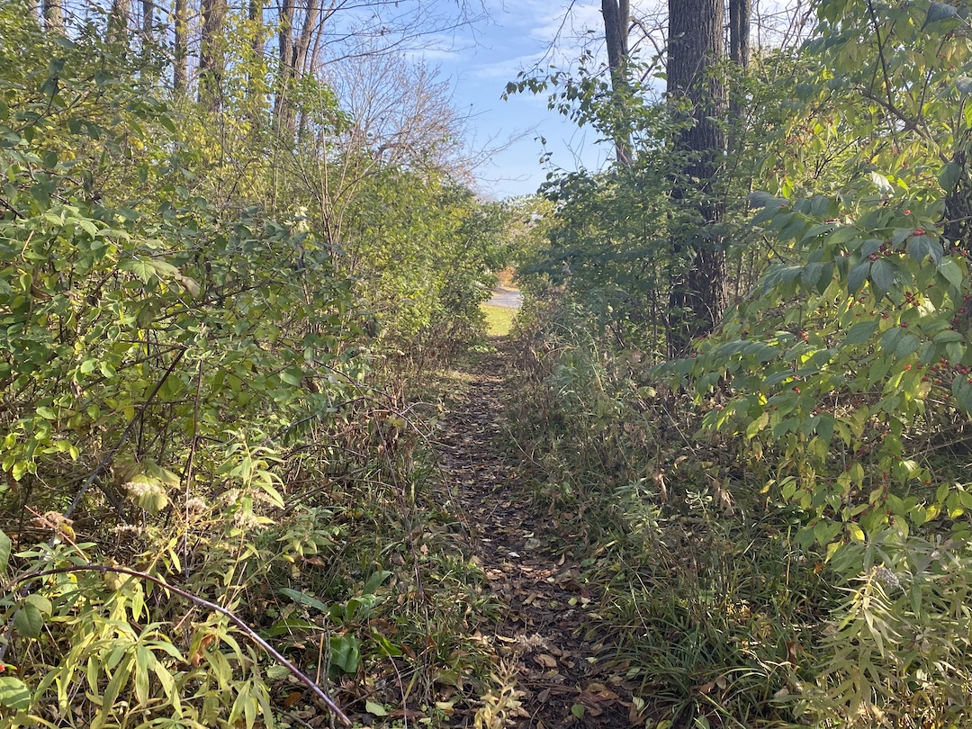
The terms “desire path” and “line of desire” bring with them a bit of a mystical feeling, as if they were something Indiana Jones would need to find a way to cross to get to the Ark of the Covenant or the Holy Grail that awaits on the other side. In reality, desire paths are not quite so fantastical.
Even if you have never heard the term desire path, odds are you’ve seen one at some point. If you’ve ever been walking around a college campus, public park, or downtown area, you have probably seen an informal dirt path that cuts a corner, or through a field, or even through a few small shrubs or bushes. This path isn’t paved and clearly wasn’t part of the original plan, but thanks to the desire of many to find the path of least resistance from point A to point B, it has emerged over the years from repeated use.
Desire paths don’t necessarily have to be so rustic, either. Lines of desire can also be represented by people using formalized roads or paths in ways they were not intended to be used, such as a service road that has become a main pedestrian thoroughfare.
In general, a desire path or line of desire represents any path that end users have determined to be the most efficient way to travel, regardless of its intended use.
“They reflect the natural tendency of where people want to move. These lines are predicated on there being barrier-free environments,” says Caitlyn Clauson, Principal, Chair at Large on Board of Directors, and Planner at Sasaki. “If areas are inaccessible, for example with a steep slope or a discontinuous sidewalk, individuals will find other routes. Desire lines are often informed by adjacent land uses, especially uses with active ground floor functions and high levels of transparency and shade that make spaces inviting and habitable.”
For many, especially planners and designers, a desire path is an unsightly reminder that a campus or downtown design plan was not as efficient and pedestrian-friendly as it could have, or perhaps should have, been. It proves just because something was designed to function a certain way, it doesn’t mean end users will necessarily follow suit.
There are two solutions to the scourge of the desire path: find a way to create a space so optimally designed desire paths won’t ever rear their ugly heads, or create a space so flexible that if a desire path does appear, it can be formalized and integrated into the design.
Sasaki’s CoMap helps spot ‘desire paths’ before they start
In order to prevent desire paths from taking shape, they need to be taken into consideration during a project’s earliest phases. “We did a feasibility study for UC San Diego in 2019 involving some developer land adjacent to campus and the campus architect was intrigued by my use of the term ‘line-of-desire’ in our initial meeting,” says Paul Schlapobersky, AIA, Associate Principal, Urban Designer, and Architect with Sasaki. “The entire study became about trying to ‘complete’ that line through a system of walkways and bridges connecting important nodes on the campus to this off-campus site and to newly-installed public transit beyond.”
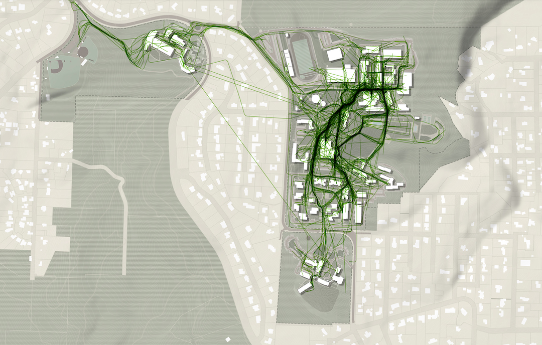
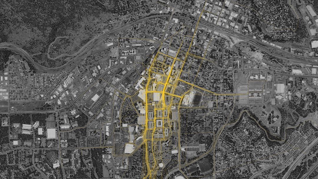
One of the main tools Sasaki uses to mitigate the informal desire path is a proprietary program developed by its in-house data and design tools group called CoMap. This collaborative mapping program generates a spatial visualization of how people experience a campus or region. When used at institutions, CoMap’s survey function allows campus communities to add notes about places or trace routes on a map of the campus. Sasaki then uses the data to inform planning recommendations.
“Many times the paths most traveled by students are not necessarily formally designed paths. The planning recommendation might therefore be to strengthen a desire line path by widening it, resurfacing it, removing an impediment, or lining it with active uses,” says Tyler Patrick, AICP, Principal, Chair of Planning and Urban Design on Board of Directors, and Planner with Sasaki. “For example, sometimes we find that service drives that are designed for vehicles are also heavily used by pedestrians, so we can instead redesign the path as more of a shared-use amenity, with aesthetic improvements to paving, lighting, etc.”
At one university, Sasaki used CoMap to learn that the formal entry to the campus was rarely used and the service drive actually served as the primary pedestrian route into campus. The design team took this information and reoriented the campus and created a new “front door” where the service drive used to be, with service access still accommodated, but in a more understated manner.
Sasaki also used CoMap in a master planning effort the firm led for Lewis & Clark College. The CoMap survey highlighted a strong north-south pedestrian route along an existing road. In response to the user feedback from CoMap, Sasaki turned the route into a primary pedestrian promenade on campus, surrounded by new residential and student life facilities.

CoMap is just one strategy the firm uses to create efficient plans without any informal desire paths. “We employ a range of strategies that include analyzing the existing system of pathways (what forms of mobility they support, their width, condition, amenities, etc.); collecting a variety of data (for instance, looking at where the concentration of classrooms is, as well as classroom utilization, to see key areas between which students may be moving); and conducting interviews and surveys to learn how pathways are used, deficiencies in the overall system, and desire paths that have not been formalized,” says Patrick.
Desire paths do not always equal good design
Just because an informal desire path appears, it does not mean it should always be formalized. Especially if the path is in direct conflict with the greater overall design scheme. “For instance, students may want to formally cross through a recreation field, but we want to maintain the field’s integrity for recreation and so we wouldn’t want to formalize that kind of desire path,” Patrick says.
Other instances may include environmental or safety concerns, such as wanting to keep a stream side riparian system intact as opposed to introducing formalized pedestrian pathways. “If a desire line promotes a path that isn’t accessible, we likely would not want to promote that movement,” adds Clauson.
The key is to balance how people want to use a given space without it turning into a free-for-all. Desire paths can, and often times do, suggest improvements for pedestrian circulation, but blindly formalizing any desire path can easily lead to a one step forward, two steps back situation. As Patrick said above, a desire path that cuts through a recreation field may prove that it is the most efficient way to traverse a campus, but formalizing it would certainly lead to more complaints about a now fractured field that is much more of an inconvenience than the lack of a formal path ever was.
As is often the case in modern design, the benefits of flexibility should never be understated. “A good campus plan should be flexible enough to accommodate evolving patterns of use and allow for the campus to integrate new ideas into the framework,” Patrick says.
The desire path, then, is representative of a larger point: There is no such thing as a perfect design, but there can be a perfectly adaptable one. Having the ability to continually adjust and formally adapt to the desires of end users is the best way to achieve the highest possible efficiency for any design.
Related Stories
| Aug 11, 2010
Giants 300 Index and Methodology
BD+C's annual Giants 300 list consists of U.S. firms that designed or constructed the largest volume of commercial, institutional, industrial, and multifamily residential buildings in 2008. Each spring, the editors survey the country's largest firms, ranking the top 300 across six categories: architects, architect/engineers, engineers, engineer/architects, contractors, and construction managers.
| Aug 11, 2010
Joint-Use Facilities Where Everybody Benefits
Shouldn’t major financial investments in new schools benefit both the students and the greater community? Conventional wisdom says yes, of course. That logic explains the growing interest in joint-use schools—innovative facilities designed with shared spaces that address the education needs of students and the community’s need for social, recreation, and civic spaces.
| Aug 11, 2010
The pride of Pasadena
As a shining symbol of civic pride in Los Angeles County, Pasadena City Hall stood as the stately centerpiece of Pasadena's Civic Center since 1927. To the casual observer, the rectangular edifice, designed by San Francisco Classicists John Bakewell, Jr., and Arthur Brown, Jr., appeared to be aging gracefully.
| Aug 11, 2010
9 Rooftop Photovoltaic Installation Tips
The popularity of rooftop photovoltaic (PV) panels has exploded during the past decade as Building Teams look to maximize building energy efficiency, implement renewable energy measures, and achieve green building certification for their projects. However, installing rooftop PV systems—rack-mounted, roof-bearing, or fully integrated systems—requires careful consideration to avoid d...
| Aug 11, 2010
Education's Big Upgrade
Forty-five percent of the country's elementary, middle, and high schools were built between 1950 and 1969 and will soon reach the end of their usefulness, according to the 2005–2008 K-12 School Market for Design & Construction Firms, published by ZweigWhite, a Massachusetts-based market-research firm.
| Aug 11, 2010
Burr Elementary School
In planning the Burr Elementary School in Fairfield, Conn., the school's building committee heeded the words of William Wordsworth: Come forth into the light of things, let nature be your teacher. They selected construction manager Turner Construction Company, New York, and the New York office of A/E firm Skidmore, Owings & Merrill to integrate nature on the heavily wooded 15.
| Aug 11, 2010
Bronze Award: Trenton Daylight/Twilight High School Trenton, N.J.
The story of the Trenton Daylight/Twilight High School is one of renewal and rebirth—both of the classic buildings that symbolize the city's past and the youth that represent its future. The $39 million, 101,000-sf urban infill project locates the high school—which serves recent dropouts and students who are at risk of dropping out—within three existing vacant buildings.
| Aug 11, 2010
New school designs don't go by the book
America needs more schools. Forty-five percent of the nation's elementary, middle, and high schools were built between 1950 and 1969, according market research firm ZweigWhite, Natick, Mass. Yet even as the stock of K-12 schools ages and declines, school enrollments continue to climb. The National Center for Education Statistics predicts that enrollment in public K-12 schools will keep rising...
| Aug 11, 2010
Bronze Award: Lincoln High School Tacoma, Wash.
Lincoln High School in Tacoma, Wash., was built in 1913 and spent nearly a century morphing into a patchwork of outdated and confusing additions. A few years ago, the Tacoma School District picked Lincoln High School, dubbed “Old Main,” to be the first high school in the district to be part of its newly launched Small Learning Communities program.
| Aug 11, 2010
Great Solutions: Technology
19. Hybrid Geothermal Technology The team at Stantec saved $800,000 in construction costs by embedding geothermal piping into the structural piles at the WestJet office complex in Calgary, Alb., rather than drilling boreholes adjacent to the building site, which is the standard approach. Regular geothermal installation would have required about 200 boreholes, each about four-inches in diameter ...


