


Four years ago, Massachusetts Institute of Technology’s City Form Lab launched Urban Network Analysis (UNA), a city-modeling software that facilitates a mathematical analysis of relationships among elements in a complex system, like a city. The unique feature of UNA is that it incorporates activities within buildings into its analysis.
This toolbox has been popular with planners and geographers, but it requires ArcGIS10 software with an ArcGIS Network Analysis Extension.
In April, City Form Lab expanded this software’s utility by introducing UNA for Rhino 3D, a modeling software for architects, engineers, and designers.
“Our toolbox helps planners and architects analyze these relationships and quantify how intensely different routes are likely to be utilized, how visible or connected public spaces are, or how conveniently one can get from one space to another,” says Andres Sevtsuk, the principal investigator at City Form Lab and developer of the UNA tool.
In layman’s terms, the software predicts where people are likely to go once they’ve decided upon an activity, like, say, going to an ATM machine or a park. The software provides users with some idea about which ATM or park that would be. As for movements to and within buildings, UNA takes into account employee head count, a building’s value, the surrounding population, and so forth.
This app’s toolbox also computes how urban design can affect—or even dictate—pedestrian movement. Sevtsuk notes, too, that the software can be scaled to account for the diversity of movement in different cities and towns.
Sevtsuk is encouraged by the sheer amount of spatial data available about urban areas, particularly in the U.S., where “you can go to any sizable city website and download data that is necessary to calibrate any of these models.” He’s confident that this software can be used to predict movement in public or semi-public spaces such as building lobbies or shopping centers.
Related Stories

AEC Tech | Jan 27, 2023
Key takeaways from Autodesk University 2022
Autodesk laid out its long-term vision to drive digital collaboration through cloud-based solutions and emphasized the importance of connecting people, processes and data.

Digital Twin | Nov 21, 2022
An inside look at the airport industry's plan to develop a digital twin guidebook
Zoë Fisher, AIA explores how design strategies are changing the way we deliver and design projects in the post-pandemic world.

BAS and Security | Oct 19, 2022
The biggest cybersecurity threats in commercial real estate, and how to mitigate them
Coleman Wolf, Senior Security Systems Consultant with global engineering firm ESD, outlines the top-three cybersecurity threats to commercial and institutional building owners and property managers, and offers advice on how to deter and defend against hackers.

Sponsored | BIM and Information Technology | Jul 19, 2022
Why Autodesk Tandem is the best fit for your projects

Sponsored | Digital Twin | Jun 24, 2022
Pave the way for better business relationships with digital twins

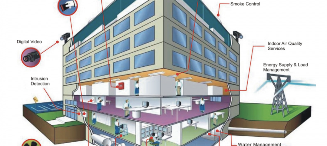
Smart Buildings | Jun 1, 2022
Taking full advantage of smart building technology
Drew Deatherage of Crux Solutions discusses where owners and AEC firms could do better at optimizing smart technology in building design and operations.

AEC Tech | Apr 19, 2022
VDC maturity and the key to driving better, more predictable outcomes
While more stakeholders across the AEC value chain embrace the concept of virtual design and construction, what is driving the vastly different results that organizations achieve? The answer lies within an assessment of VDC maturity.

BIM and Information Technology | Mar 16, 2022
Construction still lags other industries in use of technology
JBKnowledge’s latest ConTech report asserts that while contractors have made some gains, too many don’t view IT as a priority, to their detriment.
AEC Tech | Dec 16, 2021
Autodesk to Acquire Cloud Based Estimating Company ProEst
Autodesk, Inc. is acquiring ProEst, a cloud-based estimating solution that enables construction teams to create estimates, perform digital takeoffs, generate detailed reports and proposals and manage bid-day processes. Autodesk plans to integrate ProEst with Autodesk Construction Cloud, a comprehensive construction management platform connecting teams, data and workflows across the entire building lifecycle.


