

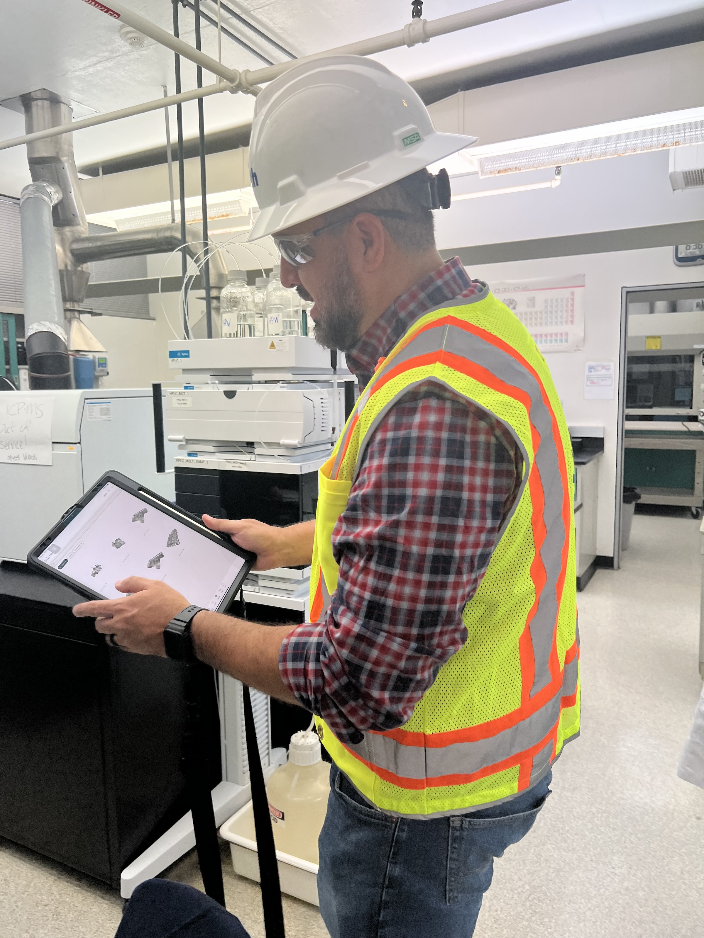
 in Virginia Beach, Va., used LIDAR and BIM technology to develop precise building and equipment data for a planned expansion of its Central Environmental Laboratory. Photo courtesy CDM Smith")
In the world of architecture and engineering, laboratory buildings are among the most complex buildings to design, plan, and document. Traditional methods rely on the use of photographs, hand drawings, or notes to document not only the building but also the equipment that makes up a laboratory. This makes the process difficult, tedious, time consuming, and even allows for documentation errors.
Currently, the most advanced state-of-the-art technology is combining Light Detection and Ranging (LIDAR) technology with Building Information Modeling (BIM) technology. LIDAR is a remote sensing method that uses light in the form of a pulsed laser to measure ranges to Earth. BIM is workflow process software used to model and optimize projects.
The latest LIDAR technology is available in the current version of hand-held devices that are used for field documentation. These devices come equipped with a very reliable LIDAR scanner, which allows one to easily document and scan in a point cloud all the existing conditions of the building like its space, function, and mechanical, electrical, and plumbing (MEP) needs.
Following the LIDAR scan, advanced software is deployed to transfer the data into a point cloud. This serves as a reliable reference to take measurements, to know where equipment is, and what its MEP needs are. Once in the point cloud, it is then exported into Autodesk ReCap Pro, and later to Autodesk Revit, which are BIM solutions.
Here it is not only inserted into the point cloud to corroborate measurements, locations and needs. It is also with the use of BIM technology and the use of special equipment families, that the foundations for the use of 7D Management of the laboratory equipment and MEP items can be developed into a 7D BIM Model.
A digital twin, which is a digital representation of a physical object or process in a digital version of its environment, can also be developed from this point. Digital twins can help an organization simulate real situations and their outcomes, ultimately allowing it to make better decisions.
LIDAR and BIM technology for building data collection
LIDAR and BIM technology such as Revit allows the existing conditions captured on site to be preserved in the digital model, allowing for measurements, orientation to aspects of the model, etc. without having to be physically on site, and more importantly, to have an orientation as to where each piece of equipment is and what the MEP needs are.
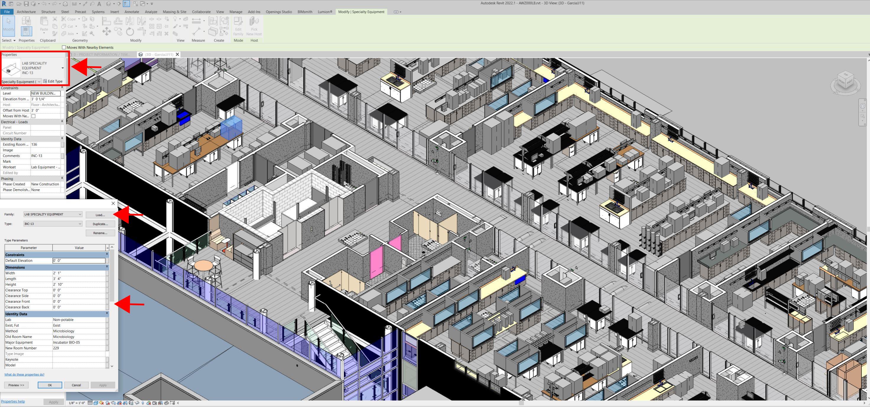
Even for any highly experienced architect or BIM modeler, just using photographs or hand drawings can be overwhelming and very complicated. Using this process, the Revit model serves as a replica of the existing conditions of each space and equipment. During a building expansion, being able to compare existing equipment in the new space is more accurate and easier to understand.
For example, Hampton Roads Sanitation District (HRSD) in Virginia Beach, Va., used LIDAR and BIM technology to develop precise building and equipment data for a planned expansion of its Central Environmental Laboratory.
The process involved meticulously scanning each space relevant to the project. This comprehensive scan aimed to capture every corner accurately. Following the scanning phase, the data was processed, generating a point cloud in ReCap Pro format. With the point cloud, we harnessed the advantages of LIDAR technology such as digitally acquiring existing conditions of the building and equipment, essentially providing a virtual on-site experience with just a click, eliminating the need for physical site visits.
This technology has enabled us to create detailed digital 3D families for every existing piece of equipment and its needs, as well as to capture more accurate existing conditions for the building. In the past, our approach relied solely on on-site measurements and photographs, leading to continuous errors and laborious, time-consuming tasks.
The previous method also necessitated numerous site visits for data verification. The implementation of this advanced technology and streamlined process has not only saved time and money but has also significantly enhanced our efficiency. For instance, all of that work required in the past to digitally model from notes, photographs, existing building plans, etc. has been condensed to the import and refinement of the point cloud data into the modeling environment.
Related Stories

Smart Buildings | Oct 26, 2020
World’s first smart building assessment and rating program released
The SPIRE Smart Building Program will help building owners and operators make better investment decisions, improve tenant satisfaction, and increase asset value.

AEC Tech | Oct 23, 2020
Risk mitigation: Seeing the forest and the tree
This case study highlights how new data analysis tools can be successfully leveraged to gain insights into some of the more abstract aspects of building evaluations.

Architects | Oct 14, 2020
The Weekly Show: AI for building facade inspections; designing a world-class architecture firm
The October 15 episode of BD+C's "The Weekly" is available for viewing on demand.

Smart Buildings | Oct 1, 2020
Smart buildings stand on good data
The coming disruption of owning and operating a building and how to stay ahead through BIM.

Digital Twin | Aug 27, 2020
The Weekly show: Digital twin technology and social equity in the AEC market
The August 27 episode of BD+C's "The Weekly" is available for viewing on demand.

AEC Tech | Apr 13, 2020
A robotic dog becomes part of Swinerton’s construction technology arsenal
Boston Dynamics, the robot’s creator, has about 100 machines in the field currently.
AEC Tech | Mar 30, 2020
Will 3D printing be an answer for building more affordable homes?
A project in southern California will put onsite fabrication to the test against other construction modes.

AEC Tech | Mar 23, 2020
Working from home? Don't miss out on the latest issue of Building Design+Construction
BD+C's March issue features the largest and most important technological innovations across the AEC industry.

AEC Tech | Mar 17, 2020
A tree grows in Stanford: CIFE, VDC, and where it all began
As our industry adopts VDC as standard practice, it is important to remember where these ideas began and continue to emanate from today.
AEC Tech | Mar 10, 2020
No labor. No infrastructure. No problem.
OpenSpace’s AI-based reality capture tool looks to make site documentation a completely passive experience.


