

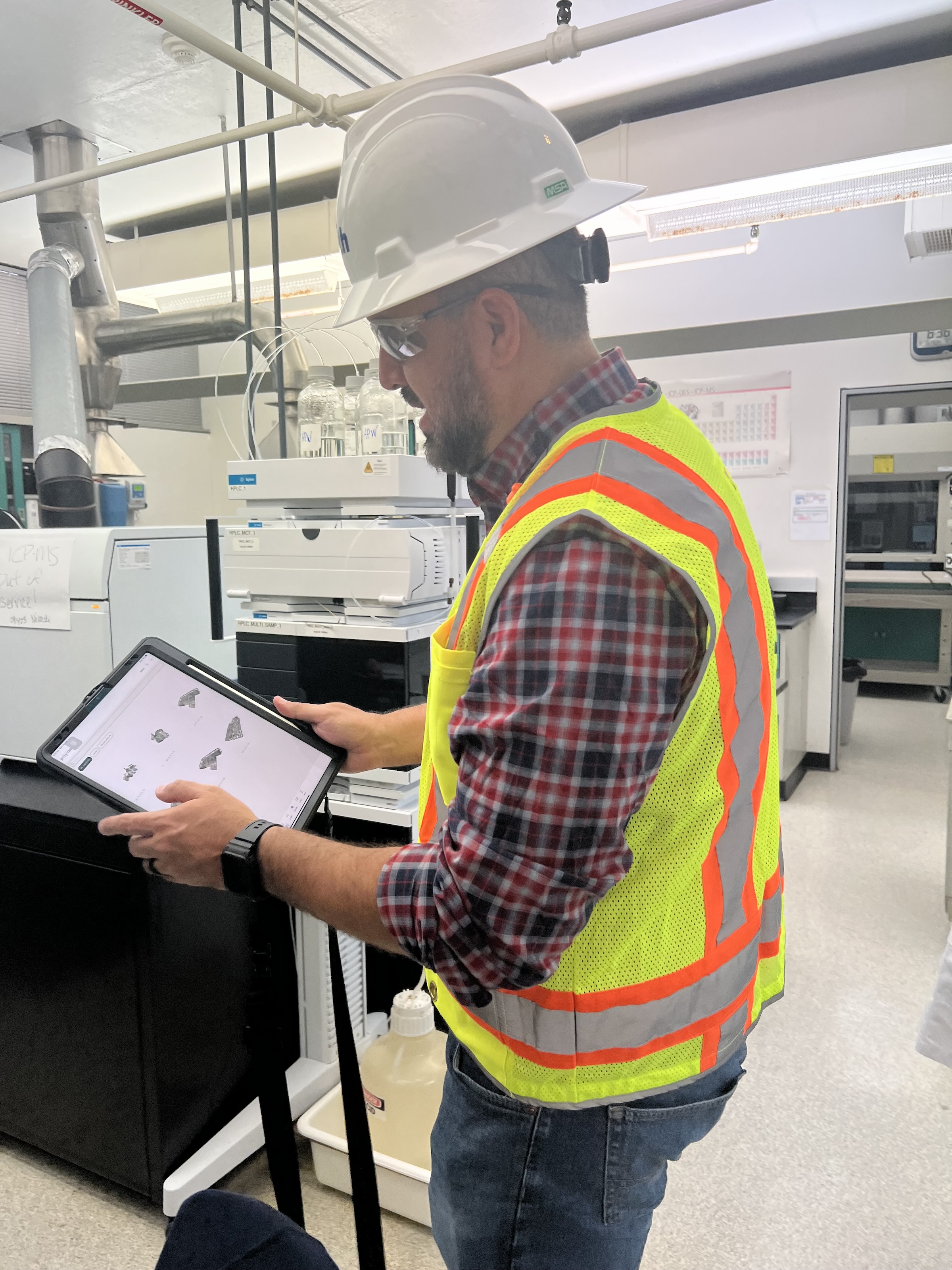
 in Virginia Beach, Va., used LIDAR and BIM technology to develop precise building and equipment data for a planned expansion of its Central Environmental Laboratory. Photo courtesy CDM Smith")
In the world of architecture and engineering, laboratory buildings are among the most complex buildings to design, plan, and document. Traditional methods rely on the use of photographs, hand drawings, or notes to document not only the building but also the equipment that makes up a laboratory. This makes the process difficult, tedious, time consuming, and even allows for documentation errors.
Currently, the most advanced state-of-the-art technology is combining Light Detection and Ranging (LIDAR) technology with Building Information Modeling (BIM) technology. LIDAR is a remote sensing method that uses light in the form of a pulsed laser to measure ranges to Earth. BIM is workflow process software used to model and optimize projects.
The latest LIDAR technology is available in the current version of hand-held devices that are used for field documentation. These devices come equipped with a very reliable LIDAR scanner, which allows one to easily document and scan in a point cloud all the existing conditions of the building like its space, function, and mechanical, electrical, and plumbing (MEP) needs.
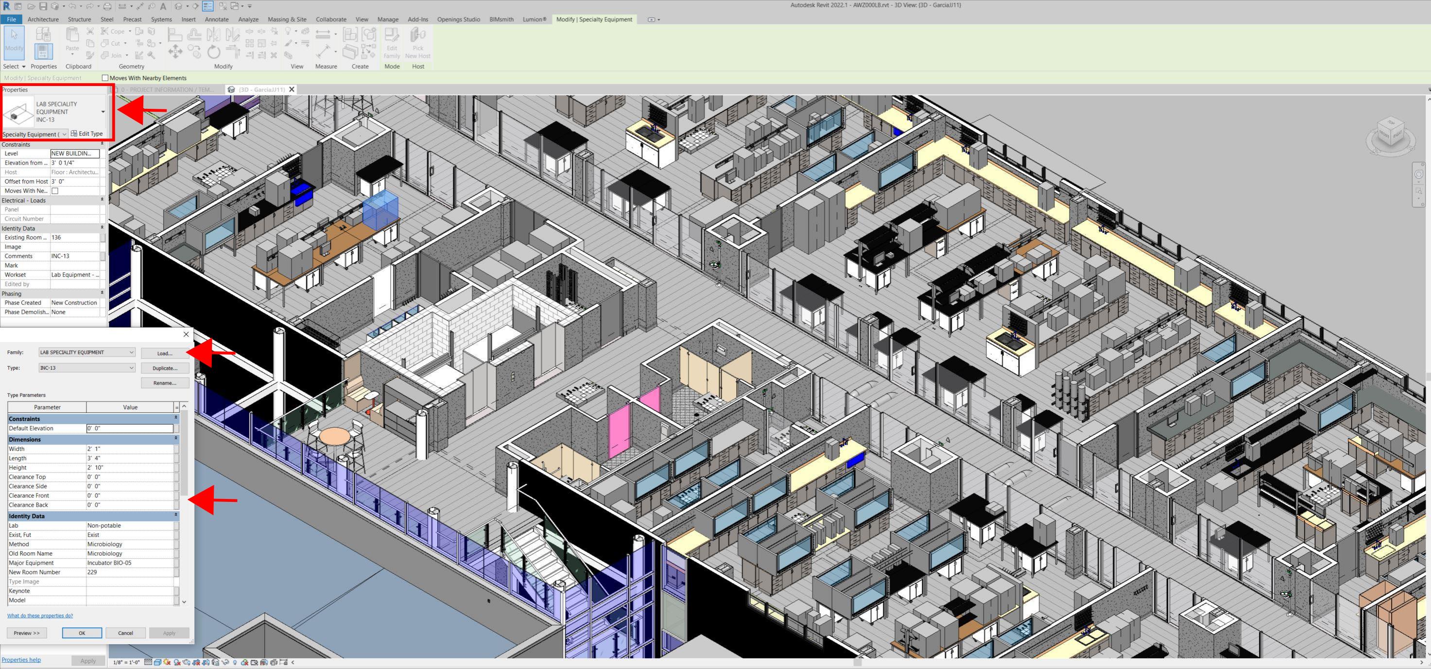
Following the LIDAR scan, advanced software is deployed to transfer the data into a point cloud. This serves as a reliable reference to take measurements, to know where equipment is, and what its MEP needs are. Once in the point cloud, it is then exported into Autodesk ReCap Pro, and later to Autodesk Revit, which are BIM solutions.
Here it is not only inserted into the point cloud to corroborate measurements, locations and needs. It is also with the use of BIM technology and the use of special equipment families, that the foundations for the use of 7D Management of the laboratory equipment and MEP items can be developed into a 7D BIM Model.
A digital twin, which is a digital representation of a physical object or process in a digital version of its environment, can also be developed from this point. Digital twins can help an organization simulate real situations and their outcomes, ultimately allowing it to make better decisions.
LIDAR and BIM technology for building data collection
LIDAR and BIM technology such as Revit allows the existing conditions captured on site to be preserved in the digital model, allowing for measurements, orientation to aspects of the model, etc. without having to be physically on site, and more importantly, to have an orientation as to where each piece of equipment is and what the MEP needs are.
Even for any highly experienced architect or BIM modeler, just using photographs or hand drawings can be overwhelming and very complicated. Using this process, the Revit model serves as a replica of the existing conditions of each space and equipment. During a building expansion, being able to compare existing equipment in the new space is more accurate and easier to understand.
For example, Hampton Roads Sanitation District (HRSD) in Virginia Beach, Va., used LIDAR and BIM technology to develop precise building and equipment data for a planned expansion of its Central Environmental Laboratory.
The process involved meticulously scanning each space relevant to the project. This comprehensive scan aimed to capture every corner accurately. Following the scanning phase, the data was processed, generating a point cloud in ReCap Pro format. With the point cloud, we harnessed the advantages of LIDAR technology such as digitally acquiring existing conditions of the building and equipment, essentially providing a virtual on-site experience with just a click, eliminating the need for physical site visits.
This technology has enabled us to create detailed digital 3D families for every existing piece of equipment and its needs, as well as to capture more accurate existing conditions for the building. In the past, our approach relied solely on on-site measurements and photographs, leading to continuous errors and laborious, time-consuming tasks.
The previous method also necessitated numerous site visits for data verification. The implementation of this advanced technology and streamlined process has not only saved time and money but has also significantly enhanced our efficiency. For instance, all of that work required in the past to digitally model from notes, photographs, existing building plans, etc. has been condensed to the import and refinement of the point cloud data into the modeling environment.
Related Stories

Codes and Standards | Apr 8, 2024
Boston’s plans to hold back rising seawater stall amid real estate slowdown
Boston has placed significant aspects of its plan to protect the city from rising sea levels on the actions of private developers. Amid a post-Covid commercial development slump, though, efforts to build protective infrastructure have stalled.

Adaptive Reuse | Apr 5, 2024
McHugh Construction completes restoration of Chicago’s historic Ramova Theatre
Adaptive reuse project turns 1929 cinema into a live performance venue, adds a brewery and a taproom, and revives the Ramova Grill in Chicago’s Bridgeport neighborhood.

Retail Centers | Apr 4, 2024
Retail design trends: Consumers are looking for wellness in where they shop
Consumers are making lifestyle choices with wellness in mind, which ignites in them a feeling of purpose and a sense of motivation. That’s the conclusion that the architecture and design firm MG2 draws from a survey of 1,182 U.S. adult consumers the firm conducted last December about retail design and what consumers want in healthier shopping experiences.

Sustainability | Apr 4, 2024
Skanska Elevates Commitment to Sustainability
Skanska, a global leader in sustainable building, has restructured its Sustainability Team to better serve client and company goals. Co-led by Steve Clem and Myrrh Caplan, who together bring decades of experience, the team will allow Skanska to continue to set the bar for the industry.

Codes and Standards | Apr 4, 2024
How Washington, D.C.'s Zero Waste DC Plan impacts building owners and design professionals
On February 8, 2024, Mayor Muriel Bowser presented the Zero Waste DC Plan to the Council, outlining policies, programs, and initiatives to meet the District’s aim of reducing per capita waste generation by 15% and transitioning from a disposable culture to a circular economy. Of the 43 actions in the plan, a handful are essential for building owners and design professionals to know about now.

Healthcare Facilities | Apr 3, 2024
Foster + Partners, CannonDesign unveil design for Mayo Clinic campus expansion
A redesign of the Mayo Clinic’s downtown campus in Rochester, Minn., centers around two new clinical high-rise buildings. The two nine-story structures will reach a height of 221 feet, with the potential to expand to 420 feet.

K-12 Schools | Apr 1, 2024
High school includes YMCA to share facilities and connect with the broader community
In Omaha, Neb., a public high school and a YMCA come together in one facility, connecting the school with the broader community. The 285,000-sf Westview High School, programmed and designed by the team of Perkins&Will and architect of record BCDM Architects, has its own athletic facilities but shares a pool, weight room, and more with the 30,000-sf YMCA.

Market Data | Apr 1, 2024
Nonresidential construction spending dips 1.0% in February, reaches $1.179 trillion
National nonresidential construction spending declined 1.0% in February, according to an Associated Builders and Contractors analysis of data published today by the U.S. Census Bureau. On a seasonally adjusted annualized basis, nonresidential spending totaled $1.179 trillion.

Affordable Housing | Apr 1, 2024
Biden Administration considers ways to influence local housing regulations
The Biden Administration is considering how to spur more affordable housing construction with strategies to influence reform of local housing regulations.

Affordable Housing | Apr 1, 2024
Chicago voters nix ‘mansion tax’ to fund efforts to reduce homelessness
Chicago voters in March rejected a proposed “mansion tax” that would have funded efforts to reduce homelessness in the city.


