flexiblefullpage -
billboard - default
interstitial1 - interstitial
catfish1 - bottom
Currently Reading

A new volume measurement tool makes drone imagery easier to analyze

Drones

A new volume measurement tool makes drone imagery easier to analyze

DroneDeploy’s latest app is available for all mobile devices. 


By John Caulfield, Senior Editor | February 3, 2016

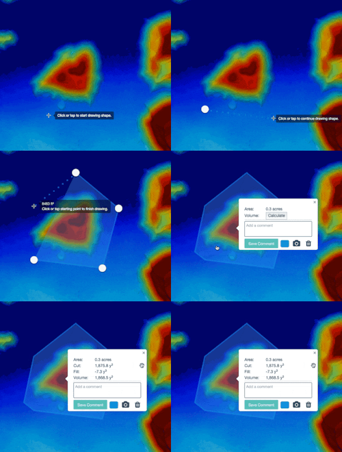
Drone imagery of map volumes—such as stockpiles of building materials—can now be measured and processed in the field, with accuracy that the software provider claims rivals laser scanning. Image: DroneDeploy

Still images that drones capture on flyovers are typically shot from above straight down, and then are “stitched” together and processed by software to create algorithms or 3D models.

Software that measures volumes within those images can be pricey, and data analysis confined to desktop computers. DroneDeploy, a provider of cloud-based software that is compatible with any UAS, is offering a more economical way to compute volumes on maps directly from the field.

On February 3, DroneDeploy made available to its current subscribers a new product that allows users to do real-time volume measurements on any mobile device.

This volumetric measurement tool includes an annotation toolbox that helps identify the flat surface around the stockpile to find the “underneath” of a pile in order to calculate its volume.

An elevation toolbox shows the elevation of every point on the map. Histograms show each elevation and the distribution of elevations on the map. The elevation tool measures the variance of each pixel to account for outliers on the site like towers, so the user can focus on measuring specifically the volume of interest within the image.

Darr Gerscovich, DroneDeploy’s Senior Vice President of Marketing, tells BD+C that this tool would be helpful for users who want to measure a mound of building materials on the site, such as a cement pile, to gauge whether there is sufficient quantity for the work being done.

This software can also give drone users a better understanding of the status of a project or whereabouts of equipment. Identifying drainage issues becomes more transparent, too.

Tests before this launch found that the volume measurements are accurate within 2% of traditional ground-base laser measurements.  

This volumetric analysis tool is available to DroneDeploy’s Pro and Precision subscribers. New subscribers can sign up for a free one-month trial, after the volumetric tool that’s part of the Pro package starts at $99 per month. The Precision package—which along with the volumetric tool offers sharper image resolution, dedicated engineering support, Ground Control Points and Custom Coord Systems—starts at $499 per month.

Gerscovich says the lower price and mobile flexibility are what separate this volumetric tool from others that are currently on the market. 
Related Stories

Drones | Dec 7, 2016

Could this idea for an Urban Droneport facilitate the future of drone-based deliveries?

The project was designed by Saúl Ajuria Fernández as part of his master’s degree in architecture.

Sponsored | Drones | Oct 25, 2016

FAA issues rules for commercial drone use

People in the construction business are finding all sorts of great applications for drones, including the inspection of remote locations, getting a high viewing angle for monitoring construction progress, or showing off an impressive aerial view of a finished project.

Drones | Jul 13, 2016

FAA issues final rule on commercial use of drones

The rule covers commercial uses for drones that weigh less than 55 pounds, and it takes effect Aug. 29.  

Drones | Apr 25, 2016

The Tremco SkyBEAM UAV is the first to be approved by the FAA for nighttime commercial operation

The SkyBEAM UAV is used for identifying energy leaks, rooftop damage, deteriorating façades, and safety issues without requiring scaffolding or cranes.

Drones | Mar 18, 2016

Drones aren't just a curiosity anymore for AEC firms

UAVs, now mounted with higher-quality image-capture cameras and software, offer crisp building and site inspections.

Retail Centers | Mar 16, 2016

Food and technology will help tomorrow’s malls survive, says CallisonRTKL

CallisonRTKL foresees future retail centers as hubs with live/work/play components. 

Drones | Mar 9, 2016

A new image-capturing platform mediates drone and cloud technologies

3DRobotics, Autodesk, and Sony launch Site Scan to speed the process of making models from field data.

boombox1 - default
boombox2 -
native1 -

More In Category


Sustainability

Increased focus on sustainability is good for business and attracting employees

A recent study, 2023 State of Design & Make by software developer Autodesk, contains some interesting takeaways for the design and construction industry. Respondents to a survey of industry leaders from the architecture, engineering, construction, product design, manufacturing, and entertainment spheres strongly support the idea that improving their organization’s sustainability practices is good for business.


halfpage1 -

Most Popular Content

  1. 2021 Giants 400 Report
  2. Top 150 Architecture Firms for 2019
  3. 13 projects that represent the future of affordable housing
  4. Sagrada Familia completion date pushed back due to coronavirus
  5. Top 160 Architecture Firms 2021