

In early 2016, Clayco, the Chicago-based design-build contractor, launched Uplift Data Partners, a full-service provider of drone technology and remote pilot training. The eight “mission” types that Uplift flies include construction and thermal inspection, as well as real estate surveying and mapping. The company can analyze data and deliver it into a BIM model. Uniquely, Uplift is able to identify and work with the “shared assets” of the AEC firms that employ it, which in Clayco’s case include its technical assurance group and virtual design and construction team.
“This is a complete, hassle-free business model,” says Suzanne El-Moursi, Uplift’s President. Her company now has 144 pilots nationwide and plans to more than double its unmanned aircraft systems (UAS) to 17 by mid-year.
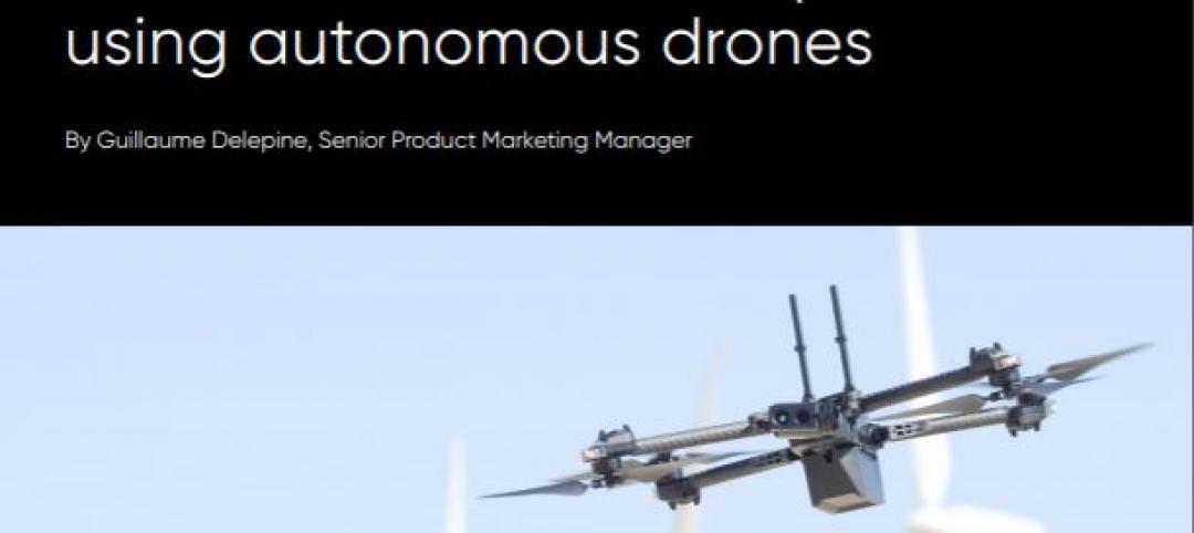
Uplift accentuates how drone technology is becoming an essential arrow in AEC teams’ reality-capture quivers. Goldman Sachs Research estimates that, between 2016 and 2020, the U.S. construction sector alone could spend $1.3 billion to purchase 44,300 drones and supporting equipment and software. Global spending on drones during that period could exceed $11 billion for 372,120 units.
As the Federal Aviation Administration continues to liberalize its rules on who can fly drones, and where, more AEC firms are jumping into this technology for everything from marketing to tracking job site progress to enhancing their ability to design and build projects.
Consigli Construction, an early drone adopter, grounded its birds when the FAA started clamping down on unauthorized flights by uncertified pilots. After the FAA issued its Part 107 rules last year, Consigli started flying again. It now has two drones and one certified operator, and plans to add at least three more pilots. It mostly uses drones for tracking construction progress and documentation. “If we have a significant event on job site, we want to get video,” says Andy Deschenes, Consigli’s Director of Project Services and Innovation.
DPR Construction’s Dallas office has been using drones for about 10 months, and currently has three UASes and five certified pilots. Field engineer Jarvis Wharton says his office uses drones to conduct weekly flights over sites for aerial mapping and earth surveys, as well as for identifying where utilities are, and overlaying that information with existing documentation and photos.
Three factors—speed, cost, and flexibility—attract AEC firms to drones. Dick Zhang, Founder and CEO of Identified Technologies, a Pittsburgh-based service provider that handles every aspect of workflow, from flight plans to data analysis, claims that a single “boomerang” drone can survey a 100-acre construction site in just nine minutes. Wharton contends that a 30-minute drone flight over 50 acres will yield about 20 million points of data (compared to 500–1,000 data points using traditional land survey methods), which can be “stitched” together through photogrammetry to create 3D imagery within 12 hours.
Harley Ellis Devereaux is working on a project that involves six buildings going up simultaneously. Drone technology has been “extremely useful” for generating progress reports, says Jason Rostar, HED’s Corporate Design Technology Leader. “From a pure documentation and marketing standpoint, we’re seeing a lot more drone use in the field.”
Last year, Birmingham, Ala.–based construction firm Brasfield & Gorrie—one of the first contractors in that state to be licensed to operate drones—used UASes to map more than 1,500 acres on 29 job sites. As of late 2016, it had seven certified pilots and five drones, and plans to invest in at least 10 more UASes this year. The goal: to have a drone operating on each one of the firm’s 200-plus active sites.
“We’re seeing exponential demand for drones on our projects, being driven by our internal teams and externally by our clients,” says Hunter Cole, a Virtual Design Coordinator with Brasfield & Gorrie.
Speaking at Autodesk University’s annual event in Las Vegas last fall, Cole explained that the value of drone technology is manifest in its almost instant payoff and “deeper project insight.” The output from drones can encompass high-resolution aerial progress photos and 4K videos, orthomosaic and heat maps, and point clouds that can be aligned with 3D models.
Brasfield & Gorrie has flown drones over a 62-acre hospital project in Apopka, Fla., to determine how much dirt would be excavated. Drones, in combination with BIM models, helped the firm confirm crane placement and clearances on another project, in Atlanta. The firm can also load 3D imagery captured by sensor-mounted drones into virtual-reality headsets, so design teams miles away can better understand the job site. “It’s like inviting someone to your Dropbox,” quipped Cole.
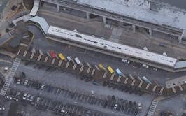

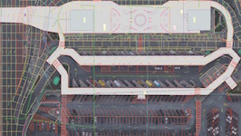 Autodesk, Atkins, 3D Robotics, and NextATL conducted the first FAA-approved drone mission in construction of Class B airspace on airport property. The January 10 mission flew over 40 acres at Atlanta’s Hartsfield-Jackson International Airport.Images courtesy of Autodesk and 3DR.
USING Drone Video to highlight your company’s expertise
Drone technology lets contractors show off their professionalism. One of Consigli’s recent clients was concerned about a specific detail for a parking garage in Natick, Mass.: the gap between the precast exterior concrete wall and the floor parking slab, which for maintenance reasons needs to be positioned precisely. “We got a great drone shot of the subcontractor installing this, and we included it in our monthly report. The owner was thrilled,” says Deschenes.
Level 10 Construction’s office in San Diego uses drones primarily for marketing. “We can take images, put them on an iPad or laptop, and show them to people without taking them to the job site,” says Bob Maxwell, Level 10’s SVP of Business Development. “We can string together videos to tell a story.”
SD Aerial Media produces Level 10’s presentations from drone-captured imagery. Its Director of Business Development, Garrett Hurley, says most AEC firms aren’t fully aware yet of the marketing capabilities of this technology. For example, he’s overlapped 3D animation with drone-generated 3D photography.
SD Aerial also works for Level 10’s Northern California division, which deploys drone technology for a variety of purposes that include educating its workers about what they might encounter in the field. In San Francisco, one of Level 10’s projects is 181 Fremont, which, at 800 feet in height, will be that city’s third-tallest building. One particularly complex video combined drone- and GoPro-captured imagery to show how Level 10 constructed a hydraulic gantry lift on rollers to move a 50,000-pound node across the 20th-story floor plate.
Another video, from 2015, showed how drones helped to document the testing of a fall-protection system that Level 10’s Senior Superintendent Chris Wilcox concocted, in this case to shield an active daycare center operating on the roof of a building 20 feet from 181 Fremont. “The ultimate goal is to help the engineering department as much as the marketing department,” says Nate Seifert, a subcontractor who supervises A/V support for Level 10 in Northern California.
Mixing UAS with other reality data capture tools
The latest evolution in drone technology for construction finds AEC firms integrating UAS technology with other reality-capture and processing tools to create better 3D models.
Autodesk, Case Technologies, and the Volterra-Detroit Foundation spent two weeks last fall in Volterra, Italy, to 3D scan key historical and archeological sites using drones, photogrammetry, and laser scanners, together with Autodesk ReCap 360 software.
The big advantage of using drones, says Tristan Randall, Autodesk’s Strategic Projects Executive, was their flexibility and versatility. “It would have been impossible and dangerous trying to get laser scanners on top of the roof of some buildings,” he recalls. “It really comes down to access, and capturing a very large area in a short time.”
There’s still a gulf in image quality between laser scans—whose tolerances are measured in millimeters—and what’s captured by drone-mounted cameras and sensors, whose accuracy is sometimes measured in inches.
Most AEC sources, though, aren’t overly concerned about this disparity, and expect image quality to improve as better, lighter drone-mounted cameras and sensors come onto the market.
“You have to have the right tool for the right job,” says Kapil Khanna, Director of Design and Construction with Clayco. “If we hire Uplift for a project that doesn’t even have topographic information yet, drone data that’s within a foot at least gets the ball rolling.” But more precise terrestrial laser scanning was essential, he says, on a recent project in Chicago whose developer wanted to preserve the façade of an existing building.
Of greater concern among AEC firms is how to manage the torrent of data they are capturing from all sources. The Volterra project, to cite one example, created 350 scans and 750 gigabytes of data, says Randall.
Bob Hanson, SVP and Practice Leader for Geospatial Information Technology with Michael Baker International, a Pittsburgh-based engineering and consulting services firm, explains that data multiplies as drone-generated information is turned into a mesh, point cloud, colorized point cloud, 3D model, and then filtered through virtual or augmented reality. The future, he believes, inevitably lies in rapid processing through more powerful data centers.
Skanska is exploring how to wrangle data it collects using Smartvid.io, a machine-learning platform that uses pattern and specification recognition and interpretation software to organize, sort, and recall pertinent visual content for quicker searches by its project team members, according to Tony Colonna, Skanska’s SVP of Innovation Construction Solutions.
 This drone image, from a 400-acre solar site mapping exercise, shows preconstuction directly following machine-control grading on a portion of the site. Image courtesy Mortenson Construction.
More operational rule changes expected from the faa
Data management is only one area where AEC sources anticipate improvements in drone technology. Longer battery life is on everyone’s wish list, as are lighter, more dexterous cameras, scanners, and sensors.
Last November, Michael Baker International started integrating 35-mm thermal cameras onto its Topcon 8 drones to inspect concrete and pipe installations for heat loss. Hanson says this camera is particularly good for photogrammetry because it has a 30-time zoom, and produces images with 640x512 pixel density.
Uplift’s El-Moursi awaits the day when broader job site bandwidth allows drones to beam information while in flight directly to operators and modelers in the field. Deschenes envisions drones being used to generate preconstruction survey videos that his firm would make available to subs bidding on the project.
AEC firms and legal experts foresee the FAA loosening its requirements for remote operator certification and for flying drones beyond an operator’s sight range. Collision avoidance sensors already exist, some for under $1,000, but Identified Technologies’ Zhang sees the next horizon for drones being directional and sensor technology that allows the machines to operate in closed or confined environments with “situational awareness.”
The thinking is that the FAA will also make changes to current rules that restrict drones from flying over people who aren’t involved in a project, or flying closer than five nautical miles from an airport.
Michael Baker recently received an airspace waiver to fly UAS missions over a 3,000-sf runway expansion at Hartsfield-Jackson Atlanta International Airport. Last January, Autodesk—working with 3DR, Atkins, and NextATL—flew the first FAA-approved commercial drone mission over Class B airspace in support of the ongoing expansion of that airport. The project, called UAV Lighthouse, had drones capture images over 40 acres to create 3D models of airport property, which could be used to design and build new structures.
Related Stories

AEC Innovators | Feb 28, 2024
How Suffolk Construction identifies ConTech and PropTech startups for investment, adoption
Contractor giant Suffolk Construction has invested in 27 ConTech and PropTech companies since 2019 through its Suffolk Technologies venture capital firm. Parker Mundt, Suffolk Technologies’ Vice President–Platforms, recently spoke with Building Design+Construction about his company’s investment strategy.

Drone Software | Jun 12, 2023
Drones take site assessments to new heights
Eric Vallejo, Director of Reality Capture and Geospatial Solutions, IMEG Corp., discusses strategies for using visualization and reality capture.

Sustainability | May 1, 2023
Increased focus on sustainability is good for business and attracting employees
A recent study, 2023 State of Design & Make by software developer Autodesk, contains some interesting takeaways for the design and construction industry. Respondents to a survey of industry leaders from the architecture, engineering, construction, product design, manufacturing, and entertainment spheres strongly support the idea that improving their organization’s sustainability practices is good for business.

AEC Tech | May 1, 2023
Utilizing computer vision, AI technology for visual jobsite tasks
Burns & McDonnell breaks down three ways computer vision can effectively assist workers on the job site, from project progress to safety measures.

AEC Tech | Jan 27, 2023
Key takeaways from Autodesk University 2022
Autodesk laid out its long-term vision to drive digital collaboration through cloud-based solutions and emphasized the importance of connecting people, processes and data.

Giants 400 | Nov 14, 2022
4 emerging trends from BD+C's 2022 Giants 400 Report
Regenerative design, cognitive health, and jobsite robotics highlight the top trends from the 519 design and construction firms that participated in BD+C's 2022 Giants 400 Report.

Contractors | Nov 14, 2022
U.S. construction firms lean on technology to manage growth and weather the pandemic
In 2021, Gilbane Building Company and Nextera Robotics partnered in a joint venture to develop an artificial intelligence platform utilizing a fleet of autonomous mobile robots. The platform, dubbed Didge, is designed to automate construction management, maximize reliability and safety, and minimize operational costs. This was just one of myriad examples over the past 18 months of contractor giants turning to construction technology (ConTech) to gather jobsite data, manage workers and equipment, and smooth the construction process.

AEC Tech | Dec 8, 2020
COVID-19 affects the industry’s adoption of ConTech in different ways
A new JLL report assesses which tech options got a pandemic “boost.”


