

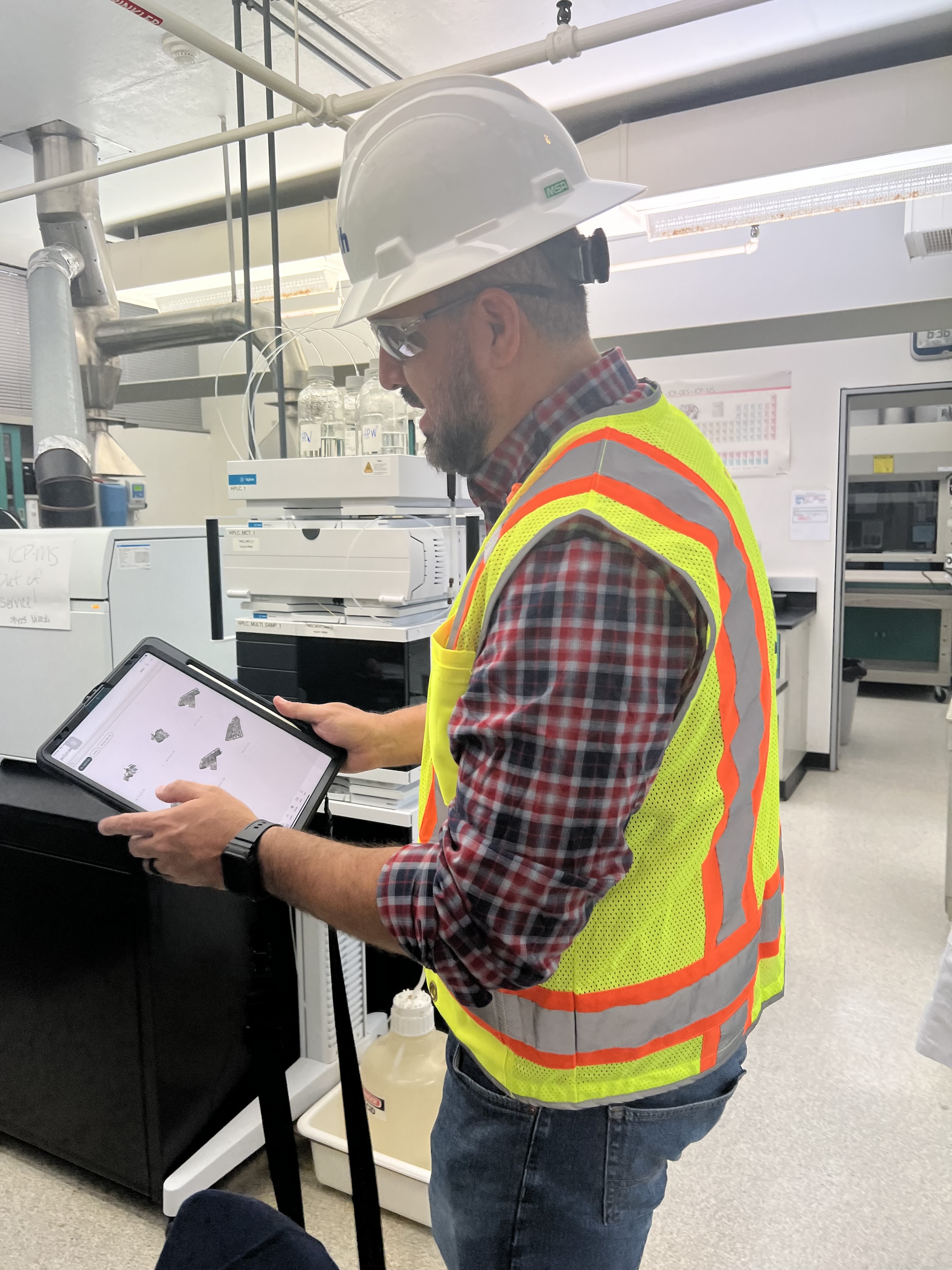
 in Virginia Beach, Va., used LIDAR and BIM technology to develop precise building and equipment data for a planned expansion of its Central Environmental Laboratory. Photo courtesy CDM Smith")
In the world of architecture and engineering, laboratory buildings are among the most complex buildings to design, plan, and document. Traditional methods rely on the use of photographs, hand drawings, or notes to document not only the building but also the equipment that makes up a laboratory. This makes the process difficult, tedious, time consuming, and even allows for documentation errors.
Currently, the most advanced state-of-the-art technology is combining Light Detection and Ranging (LIDAR) technology with Building Information Modeling (BIM) technology. LIDAR is a remote sensing method that uses light in the form of a pulsed laser to measure ranges to Earth. BIM is workflow process software used to model and optimize projects.
The latest LIDAR technology is available in the current version of hand-held devices that are used for field documentation. These devices come equipped with a very reliable LIDAR scanner, which allows one to easily document and scan in a point cloud all the existing conditions of the building like its space, function, and mechanical, electrical, and plumbing (MEP) needs.
Following the LIDAR scan, advanced software is deployed to transfer the data into a point cloud. This serves as a reliable reference to take measurements, to know where equipment is, and what its MEP needs are. Once in the point cloud, it is then exported into Autodesk ReCap Pro, and later to Autodesk Revit, which are BIM solutions.
Here it is not only inserted into the point cloud to corroborate measurements, locations and needs. It is also with the use of BIM technology and the use of special equipment families, that the foundations for the use of 7D Management of the laboratory equipment and MEP items can be developed into a 7D BIM Model.
A digital twin, which is a digital representation of a physical object or process in a digital version of its environment, can also be developed from this point. Digital twins can help an organization simulate real situations and their outcomes, ultimately allowing it to make better decisions.
LIDAR and BIM technology for building data collection
LIDAR and BIM technology such as Revit allows the existing conditions captured on site to be preserved in the digital model, allowing for measurements, orientation to aspects of the model, etc. without having to be physically on site, and more importantly, to have an orientation as to where each piece of equipment is and what the MEP needs are.
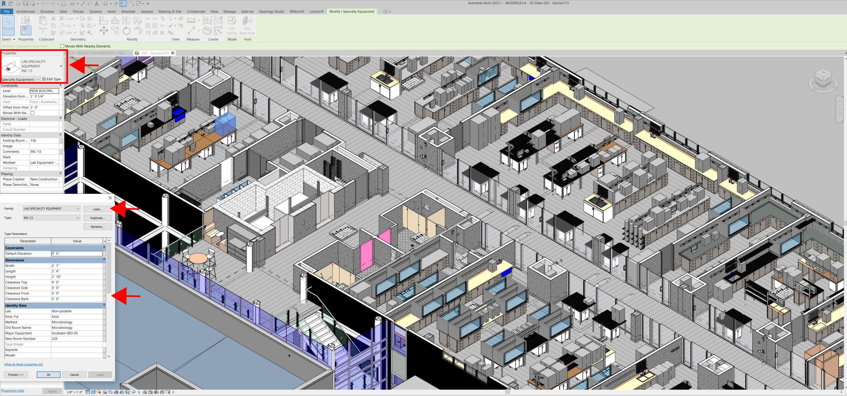
Even for any highly experienced architect or BIM modeler, just using photographs or hand drawings can be overwhelming and very complicated. Using this process, the Revit model serves as a replica of the existing conditions of each space and equipment. During a building expansion, being able to compare existing equipment in the new space is more accurate and easier to understand.
For example, Hampton Roads Sanitation District (HRSD) in Virginia Beach, Va., used LIDAR and BIM technology to develop precise building and equipment data for a planned expansion of its Central Environmental Laboratory.
The process involved meticulously scanning each space relevant to the project. This comprehensive scan aimed to capture every corner accurately. Following the scanning phase, the data was processed, generating a point cloud in ReCap Pro format. With the point cloud, we harnessed the advantages of LIDAR technology such as digitally acquiring existing conditions of the building and equipment, essentially providing a virtual on-site experience with just a click, eliminating the need for physical site visits.
This technology has enabled us to create detailed digital 3D families for every existing piece of equipment and its needs, as well as to capture more accurate existing conditions for the building. In the past, our approach relied solely on on-site measurements and photographs, leading to continuous errors and laborious, time-consuming tasks.
The previous method also necessitated numerous site visits for data verification. The implementation of this advanced technology and streamlined process has not only saved time and money but has also significantly enhanced our efficiency. For instance, all of that work required in the past to digitally model from notes, photographs, existing building plans, etc. has been condensed to the import and refinement of the point cloud data into the modeling environment.
Related Stories

Office Buildings | Mar 21, 2024
Corporate carbon reduction pledges will have big impact on office market
Corporate carbon reduction commitments will have a significant impact on office leasing over the next few years. Businesses that have pledged to reduce their organization’s impact on climate change must ensure their next lease allows them to show material progress on their goals, according to a report by JLL.

Adaptive Reuse | Mar 21, 2024
Massachusetts launches program to spur office-to-residential conversions statewide
Massachusetts Gov. Maura Healey recently launched a program to help cities across the state identify underused office buildings that are best suited for residential conversions.

Legislation | Mar 21, 2024
Bill would mandate solar panels on public buildings in New York City
A recently introduced bill in the New York City Council would mandate solar panel installations on the roofs of all city-owned buildings. The legislation would require 100 MW of solar photovoltaic systems be installed on public buildings by the end of 2025.

Office Buildings | Mar 21, 2024
BOMA updates floor measurement standard for office buildings
The Building Owners and Managers Association (BOMA) International has released its latest floor measurement standard for office buildings, BOMA 2024 for Office Buildings – ANSI/BOMA Z65.1-2024.
Healthcare Facilities | Mar 18, 2024
A modular construction solution to the mental healthcare crisis
Maria Ionescu, Senior Medical Planner, Stantec, shares a tested solution for the overburdened emergency department: Modular hub-and-spoke design.

Codes and Standards | Mar 18, 2024
New urban stormwater policies treat rainwater as a resource
U.S. cities are revamping how they handle stormwater to reduce flooding and capture rainfall and recharge aquifers. New policies reflect a change in mindset from treating stormwater as a nuisance to be quickly diverted away to capturing it as a resource.

Plumbing | Mar 18, 2024
EPA to revise criteria for WaterSense faucets and faucet accessories
The U.S. Environmental Protection Agency (EPA) plans to revise its criteria for faucets and faucet accessories to earn the WaterSense label. The specification launched in 2007; since then, most faucets now sold in the U.S. meet or exceed the current WaterSense maximum flow rate of 1.5 gallons per minute (gpm).

MFPRO+ New Projects | Mar 18, 2024
Luxury apartments in New York restore and renovate a century-old residential building
COOKFOX Architects has completed a luxury apartment building at 378 West End Avenue in New York City. The project restored and renovated the original residence built in 1915, while extending a new structure east on West 78th Street.

Construction Costs | Mar 15, 2024
Retail center construction costs for 2024
Data from Gordian shows the most recent costs per square foot for restaurants, social clubs, one-story department stores, retail stores and movie theaters in select cities.

Healthcare Facilities | Mar 15, 2024
First comprehensive cancer hospital in Dubai to host specialized multidisciplinary care
Stantec was selected to lead the design team for the Hamdan Bin Rashid Cancer Hospital, Dubai’s first integrated, comprehensive cancer hospital. Named in honor of the late Sheikh Hamdan Bin Rashid Al Maktoum, the hospital is scheduled to open to patients in 2026.


