

The new analysis reveals that the inherent value of Geographic Information Systems (GIS) is well understood by AEC firms, and those that use it report achieving important benefits. Even firms and individuals currently not using GIS have a favorable view of its potential, according to the report released by Dodge Data & Analytics.
Those benefits include improved productivity and client satisfaction, the ability to offer more services; reduced conflicts, field coordination problems, or changes during construction; and increased ability to manage project complexity.
The report states that designers and contractors also see value in their entire teams using GIS data, especially when that sharing engages owners. But when using GIS across project teams, interoperability is key to sustaining contractor and designer workflows. The report notes that the industry has been investing in training to find qualified staff to manage GIS.
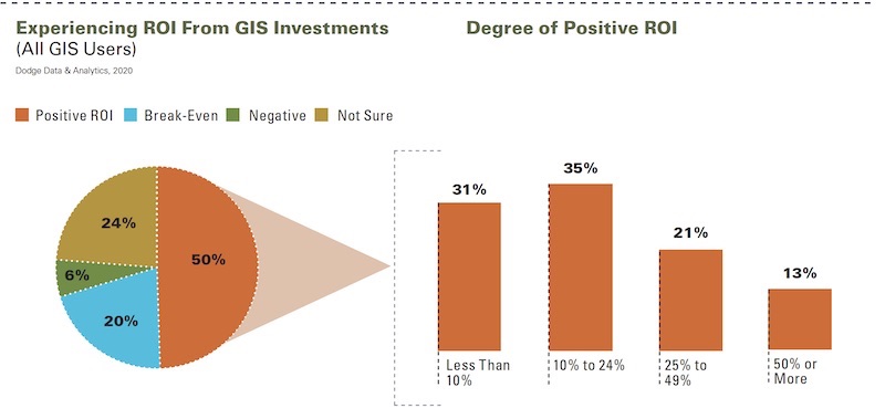
A strong majority of respondents are experiencing double-digit returns on investment from using ROI.
The data and analysis in this report—titled “The Business Value of GIS for Design and Construction”—are based on responses to an online survey conducted in August and September 2020. The survey’s 473 respondents include 228 architects, 43 civil or structural engineers, 33 engineering consultants, 113 GCs or CMs, and 56 specialty trade contractors.
Respondents were eligible to take the survey if they had experience in using relevant software, such as CAD drafting, 2- and 3-D modeling apps, data visualization and mapping, and/or collaboration tech or project management software.
The report includes interviews with Donna Huey, Senior Vice President and Director of Client Technologies at Atkins North America; Cory Dippold, PE, Vice President-Special Projects Applications, Mott MacDonald; and Sanjay Kumar, founder and CEO, Geospatial Media and Communications.
Access to the Dodge report requires registration. Autodesk and Esri provided funding and support for the report.
ROI CONNECTED TO FREQUENCY OF USE
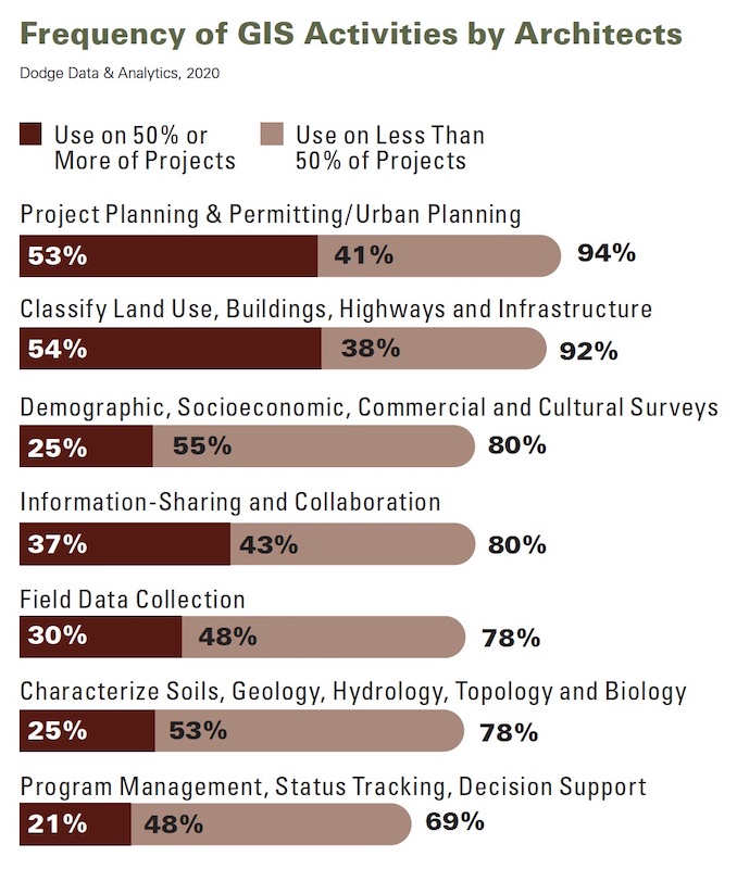
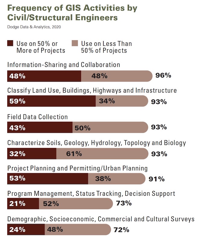
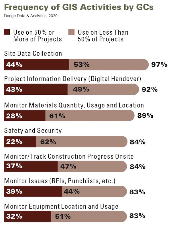
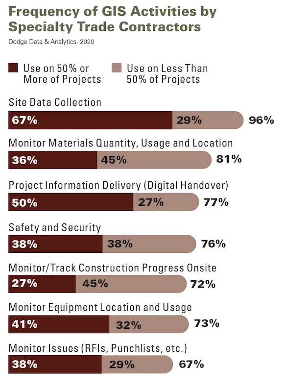
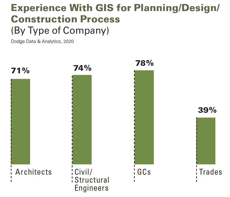
The charts above show the frequency of GIS usage by company type, and illustrate how each company's priorities differ in GIS's application.
The Dodge report touches specifically on the integration of GIS and BIM, the benefits of GIS on project processes and outcomes, and how GIS helps reduce risk and enhance a project’s sustainability and disaster resilience. Client satisfaction is at the top of respondents’ list of market-related benefits from using GIS. Digital tools like GIS are also helping AEC firms keep jobsites safe and productivity high during the coronavirus pandemic.
Over the past three years, more than half of the survey’s respondents said their companies had invested in software that supports the use of GIS, and 36% said they’d invested in training, too, during that period. Among the 50% of respondents who say they’ve experienced positive returns on their investments, nearly 70% estimates that the degree of positive returns exceeds 10%.
The report implies a connection between ROI and the frequency of GIS use by project team members. Nearly two-fifths (38%) of the architects who replied to the survey state that on at least half of their projects, other design firms or consultants on the design team use GIS.
INTEROPERABILITY STILL PROBLEMATIC
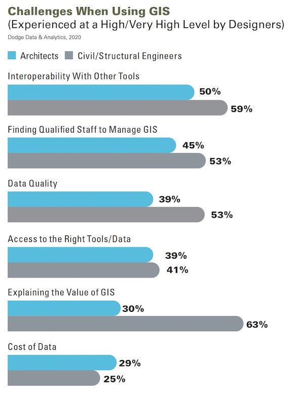
Using GIS with other digital tools, and finding people who are familiar with the software, pose limits to its wider application, especially when it comes to sharing data with teams.
Engineers state that owners now expect the design team to provide updates back to the GIS as part of the collaborative process during design. And nearly all contractors surveyed (at least 96%) report that a project’s GC is either using GIS or takes advantage of GIS in design documents. For contractors, the most valuable engagement is when the design team has used GIS in its design.
Interoperability with other digital tools, however, continues to be the biggest roadblock to greater use of GIS; at least half of the architects and engineers surveyed cited this as a challenge. Other impediments include finding qualified staff, the quality of the data, and access to the right tools for projects. Finding staff is the greatest challenge for contractors and specialty trades.
Better interoperability, in fact, would drive greater use of GIS, say 54% of the survey’s respondents. Another driver would be more accurate and reliable GIS information, say 36% of respondents.
Data quality is particularly critical when AEC firms deploy tools like GIS and BIM in their smart city projects. If a building is viewed as a system, and a city a system of systems, then “The marriage of BIM and GIS makes data exchange possible across those levels of scale,” the report states. “The potential is huge,” adds Scott Edmondson, a senior planner and economist with San Francisco Planning’s data analytics group.
This marriage is less about creating a digital twin of a city than it is about making incremental improvements to existing conditions within a city, observed Stephen Brockwell, senior product owner at Esri. With data integrations across BIM and GIS, “dynamic, thriving cities have never been more possible,” said Brockwell.
EVEN NONUSERS ARE COGNIZANT OF BENEFITS
If GIS is such a great tool, what’s keeping more AEC firms form using it? There was a small group of nonusers among the survey’s respondents, and 13% of them expressed no interest in using GIS in the future, citing the lack of real application for what they do, or not enough client demand.
Conversely, 87% of nonusers say they are aware of GIS’s benefits. Fifty-five percent of nonusers say they are open to exploring GIS’s potential value to their firms.
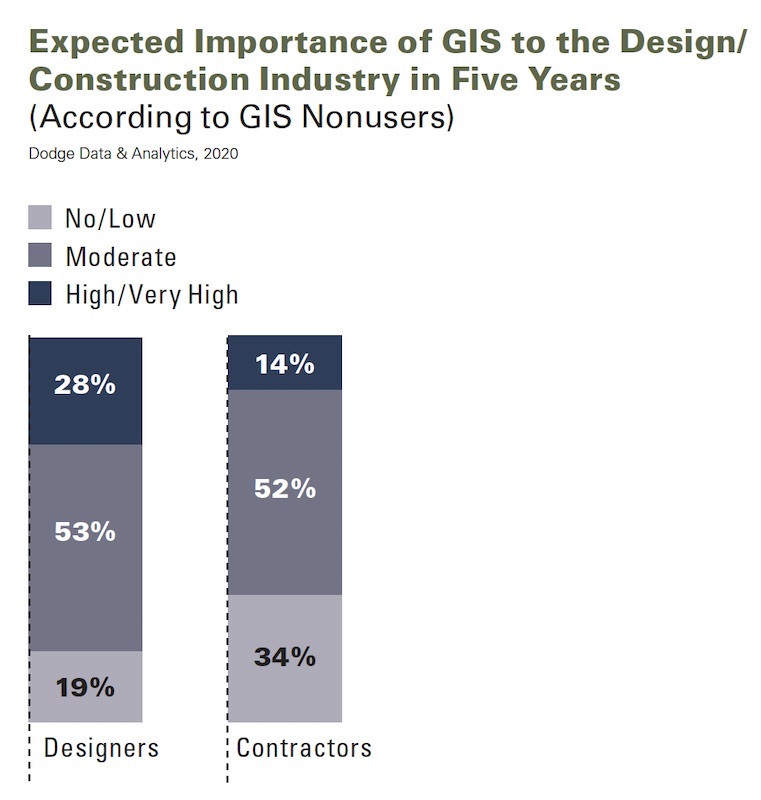
Designers are more sanguine about the future relevance of GIS for their business sector.
The extent that competitors are using GIS might eventually drive nonusers to give the tool a tryout. Other influencers for designers include improved field data collection during planning and design, and improved product understanding among stakeholders. For contractors, the biggest influence for adopting GIS is reducing the number and need for RFIs and change orders, followed by improved collaboration across and within teams.
The benefits most likely to influence adoption of GIS are led, for designers and contractors alike, by improved productivity.
While designers are generally far more enthusiastic about the importance of GIS in five years, it is clear, according to the Dodge report, that the majority of designers and contractors not using GIS currently expects it to be at least moderately important to the industry in the near future.
Related Stories

AEC Tech | Mar 7, 2018
Interoperability for the building industry – More wicked problems
This article is a follow up to Nathan Miller's 2016 article “The Wicked Problem of Interoperability”.

AEC Tech | Feb 28, 2018
Nine tips to bridge the cybernetic design gap
Unlike other technologies we have seen, augmented and virtual reality are looking to have staying power in a truly disruptive way.

AEC Tech | Jan 29, 2018
thyssenkrupp tests self-driving robot for ‘last mile’ delivery of elevator parts
“With driverless delivery robots, we could fill a gap and get spare parts from our warehouses to the jobsite faster,” said thyssenkrupp SVP Ivo Siebers.

AEC Tech | Jan 25, 2018
Four high-tech solutions to mitigate theft on the jobsite
Geo-fencing and drone surveillance are among the tech solutions for protecting jobsites from asset loss.

BD+C University Course | Jan 2, 2018
The art and science of rendering: Visualization that sells architecture [AIA course]
3D artist Ramy Hanna offers guidelines and tricks-of-the-trade to ensure that project artwork is a stunning depiction of the unbuilt space.
Reconstruction & Renovation | Dec 21, 2017
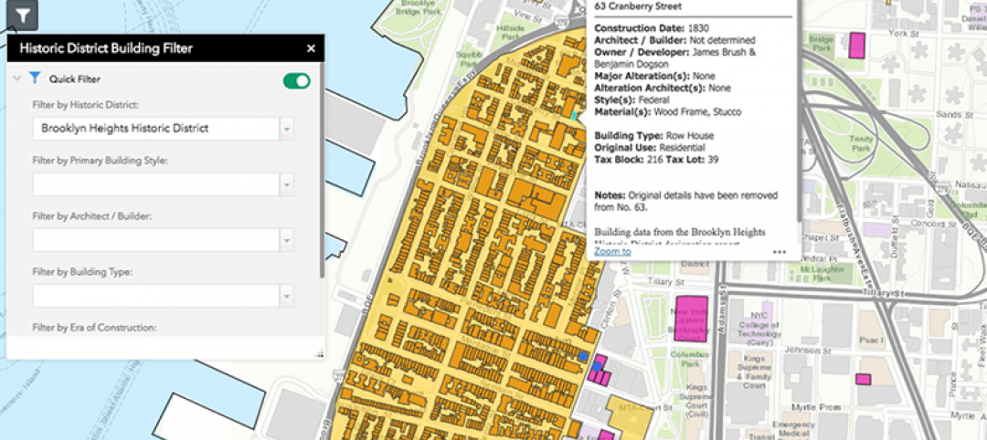
Interactive map includes detailed information on historic New York City buildings
The New York City Landmarks Preservation Commission launched a new, enhanced version of its interactive map, Discover NYC Landmarks.

AEC Tech | Dec 20, 2017
6 CFD post-processing tips to improve visualization productivity and quality
Southland Engineering’s Abdullah Karimi offers helpful tips for making computational fluid dynamics (CFD) models more productive.

Sponsored | Building Team | Nov 3, 2017
4 strategies for marketing your AEC firm
Having a clearly defined competitive brand and a fine-tuned marketing approach can give your firm a significant competitive advantage.

Sponsored | AEC Tech | Oct 19, 2017
3 reasons why your firm needs cloud software
For firms looking to propel their architectural design services to new heights and levels of sophistication, a consolidated cloud-based platform is a valuable asset.

AEC Tech | Oct 6, 2017
How professional bias can sabotage industry transformation
Professional bias can take the form of change-resistant thinking that can keep transformational or innovative ambitions at bay. Tech consultant Nate Miller presents three kinds of bias that often emerge when a professional is confronted with new technology.


